You are here: Home > Network List > TX - Texas Seismological Network Stations List
> Station WTFS Witchita Falls > Earthquake Result Viewer
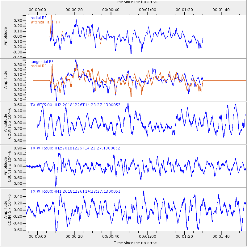
WTFS Witchita Falls - Earthquake Result Viewer
*The percent match for this event was below the threshold and hence no stack was calculated.
| Earthquake location: |
Tonga Islands |
| Earthquake latitude/longitude: |
-17.2/-173.6 |
| Earthquake time(UTC): |
2018/12/26 (360) 14:11:21 GMT |
| Earthquake Depth: |
163 km |
| Earthquake Magnitude: |
6.0 Mi |
| Earthquake Catalog/Contributor: |
NEIC PDE/pt |
|
| Network: |
TX Texas Seismological Network |
| Station: |
WTFS Witchita Falls |
| Lat/Lon: |
33.77 N/98.46 W |
| Elevation: |
277 m |
|
| Distance: |
87.6 deg |
| Az: |
53.694 deg |
| Baz: |
247.649 deg |
| Ray Param: |
$rayparam |
*The percent match for this event was below the threshold and hence was not used in the summary stack. |
|
| Radial Match: |
45.07926 % |
| Radial Bump: |
400 |
| Transverse Match: |
42.674744 % |
| Transverse Bump: |
392 |
| SOD ConfigId: |
13570011 |
| Insert Time: |
2019-05-02 04:53:59.272 +0000 |
| GWidth: |
2.5 |
| Max Bumps: |
400 |
| Tol: |
0.001 |
|
Signal To Noise
| Channel | StoN | STA | LTA |
| TX:WTFS:00:HHZ:20181226T14:23:27.130005Z | 1.2063955 | 1.3693464E-7 | 1.13507255E-7 |
| TX:WTFS:00:HH1:20181226T14:23:27.130005Z | 0.56105804 | 1.2088837E-7 | 2.1546498E-7 |
| TX:WTFS:00:HH2:20181226T14:23:27.130005Z | 0.61914605 | 1.8061345E-7 | 2.917138E-7 |
| Arrivals |
| Ps | |
| PpPs | |
| PsPs/PpSs | |


