You are here: Home > Network List > US - United States National Seismic Network Stations List
> Station AMTX Amarillo, Texas, USA > Earthquake Result Viewer
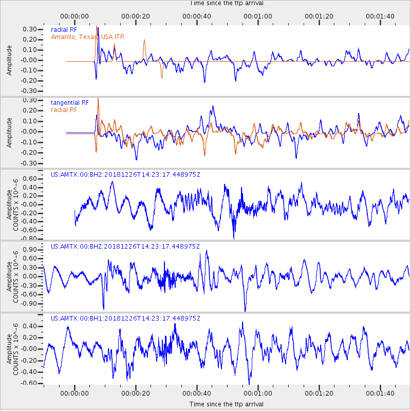
AMTX Amarillo, Texas, USA - Earthquake Result Viewer
*The percent match for this event was below the threshold and hence no stack was calculated.
| Earthquake location: |
Tonga Islands |
| Earthquake latitude/longitude: |
-17.2/-173.6 |
| Earthquake time(UTC): |
2018/12/26 (360) 14:11:21 GMT |
| Earthquake Depth: |
163 km |
| Earthquake Magnitude: |
6.0 Mi |
| Earthquake Catalog/Contributor: |
NEIC PDE/pt |
|
| Network: |
US United States National Seismic Network |
| Station: |
AMTX Amarillo, Texas, USA |
| Lat/Lon: |
34.53 N/101.41 W |
| Elevation: |
1010 m |
|
| Distance: |
85.6 deg |
| Az: |
52.029 deg |
| Baz: |
245.905 deg |
| Ray Param: |
$rayparam |
*The percent match for this event was below the threshold and hence was not used in the summary stack. |
|
| Radial Match: |
32.78215 % |
| Radial Bump: |
400 |
| Transverse Match: |
34.253685 % |
| Transverse Bump: |
400 |
| SOD ConfigId: |
13570011 |
| Insert Time: |
2019-05-02 04:54:12.030 +0000 |
| GWidth: |
2.5 |
| Max Bumps: |
400 |
| Tol: |
0.001 |
|
Signal To Noise
| Channel | StoN | STA | LTA |
| US:AMTX:00:BHZ:20181226T14:23:17.448975Z | 0.5075093 | 1.08153934E-7 | 2.131073E-7 |
| US:AMTX:00:BH1:20181226T14:23:17.448975Z | 0.27130094 | 7.5212924E-8 | 2.7723058E-7 |
| US:AMTX:00:BH2:20181226T14:23:17.448975Z | 1.5929004 | 3.329703E-7 | 2.0903397E-7 |
| Arrivals |
| Ps | |
| PpPs | |
| PsPs/PpSs | |


