You are here: Home > Network List > US - United States National Seismic Network Stations List
> Station EGMT Eagleton, Montana, USA > Earthquake Result Viewer
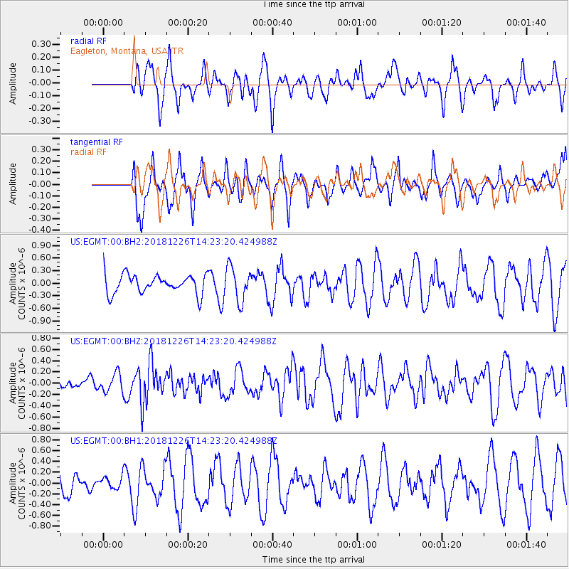
EGMT Eagleton, Montana, USA - Earthquake Result Viewer
*The percent match for this event was below the threshold and hence no stack was calculated.
| Earthquake location: |
Tonga Islands |
| Earthquake latitude/longitude: |
-17.2/-173.6 |
| Earthquake time(UTC): |
2018/12/26 (360) 14:11:21 GMT |
| Earthquake Depth: |
163 km |
| Earthquake Magnitude: |
6.0 Mi |
| Earthquake Catalog/Contributor: |
NEIC PDE/pt |
|
| Network: |
US United States National Seismic Network |
| Station: |
EGMT Eagleton, Montana, USA |
| Lat/Lon: |
48.02 N/109.75 W |
| Elevation: |
1055 m |
|
| Distance: |
86.2 deg |
| Az: |
37.147 deg |
| Baz: |
239.317 deg |
| Ray Param: |
$rayparam |
*The percent match for this event was below the threshold and hence was not used in the summary stack. |
|
| Radial Match: |
47.74737 % |
| Radial Bump: |
343 |
| Transverse Match: |
54.580036 % |
| Transverse Bump: |
392 |
| SOD ConfigId: |
13570011 |
| Insert Time: |
2019-05-02 04:54:17.111 +0000 |
| GWidth: |
2.5 |
| Max Bumps: |
400 |
| Tol: |
0.001 |
|
Signal To Noise
| Channel | StoN | STA | LTA |
| US:EGMT:00:BHZ:20181226T14:23:20.424988Z | 1.61865 | 1.7206438E-7 | 1.06301165E-7 |
| US:EGMT:00:BH1:20181226T14:23:20.424988Z | 0.40133262 | 1.3439183E-7 | 3.3486396E-7 |
| US:EGMT:00:BH2:20181226T14:23:20.424988Z | 1.5752538 | 3.3582617E-7 | 2.1318861E-7 |
| Arrivals |
| Ps | |
| PpPs | |
| PsPs/PpSs | |


