You are here: Home > Network List > UW - Pacific Northwest Regional Seismic Network Stations List
> Station UMAT Pilot Rock, OR, USA > Earthquake Result Viewer
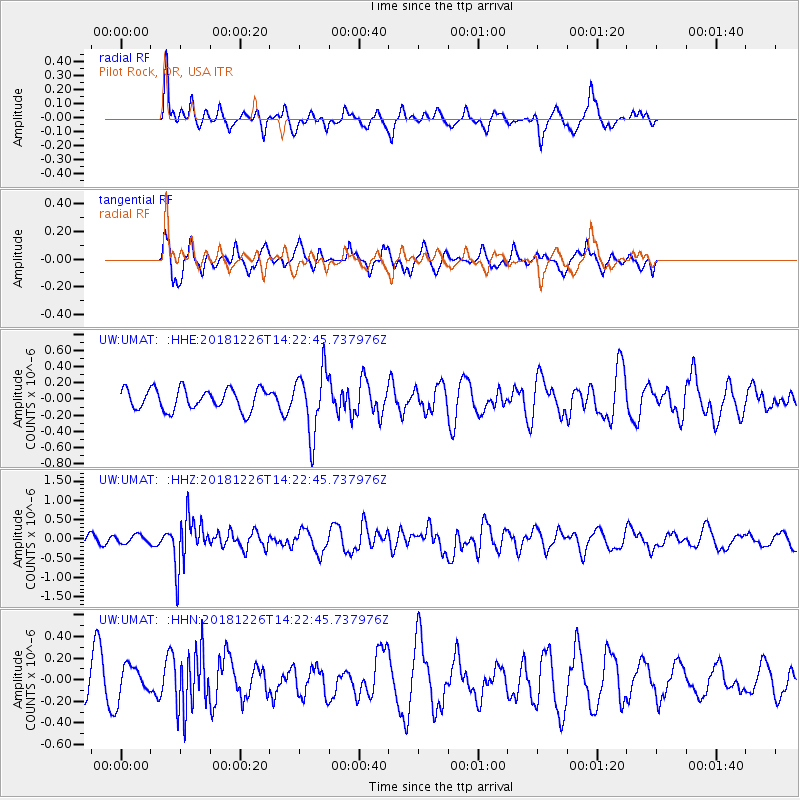
UMAT Pilot Rock, OR, USA - Earthquake Result Viewer
*The percent match for this event was below the threshold and hence no stack was calculated.
| Earthquake location: |
Tonga Islands |
| Earthquake latitude/longitude: |
-17.2/-173.6 |
| Earthquake time(UTC): |
2018/12/26 (360) 14:11:21 GMT |
| Earthquake Depth: |
163 km |
| Earthquake Magnitude: |
6.0 Mi |
| Earthquake Catalog/Contributor: |
NEIC PDE/pt |
|
| Network: |
UW Pacific Northwest Regional Seismic Network |
| Station: |
UMAT Pilot Rock, OR, USA |
| Lat/Lon: |
45.29 N/118.96 W |
| Elevation: |
1318 m |
|
| Distance: |
79.5 deg |
| Az: |
35.843 deg |
| Baz: |
232.473 deg |
| Ray Param: |
$rayparam |
*The percent match for this event was below the threshold and hence was not used in the summary stack. |
|
| Radial Match: |
52.753128 % |
| Radial Bump: |
325 |
| Transverse Match: |
65.18676 % |
| Transverse Bump: |
338 |
| SOD ConfigId: |
13570011 |
| Insert Time: |
2019-05-02 04:55:09.037 +0000 |
| GWidth: |
2.5 |
| Max Bumps: |
400 |
| Tol: |
0.001 |
|
Signal To Noise
| Channel | StoN | STA | LTA |
| UW:UMAT: :HHZ:20181226T14:22:45.737976Z | 0.67499524 | 1.0649634E-7 | 1.5777347E-7 |
| UW:UMAT: :HHN:20181226T14:22:45.737976Z | 1.3501048 | 1.4664661E-7 | 1.08618686E-7 |
| UW:UMAT: :HHE:20181226T14:22:45.737976Z | 1.0665052 | 1.2792994E-7 | 1.1995247E-7 |
| Arrivals |
| Ps | |
| PpPs | |
| PsPs/PpSs | |


