You are here: Home > Network List > TS - TERRAscope (Southern California Seismic Network) Stations List
> Station CALB Calabasas, California, USA > Earthquake Result Viewer
CALB Calabasas, California, USA - Earthquake Result Viewer
| Earthquake location: |
Near Coast Of Central Chile |
| Earthquake latitude/longitude: |
-29.0/-71.5 |
| Earthquake time(UTC): |
1995/11/01 (305) 00:35:32 GMT |
| Earthquake Depth: |
20 km |
| Earthquake Magnitude: |
6.3 MB, 6.4 MS, 6.3 UNKNOWN, 6.7 MW |
| Earthquake Catalog/Contributor: |
WHDF/NEIC |
|
| Network: |
TS TERRAscope (Southern California Seismic Network) |
| Station: |
CALB Calabasas, California, USA |
| Lat/Lon: |
34.14 N/118.63 W |
| Elevation: |
0.0 m |
|
| Distance: |
77.0 deg |
| Az: |
321.402 deg |
| Baz: |
138.763 deg |
| Ray Param: |
0.050617505 |
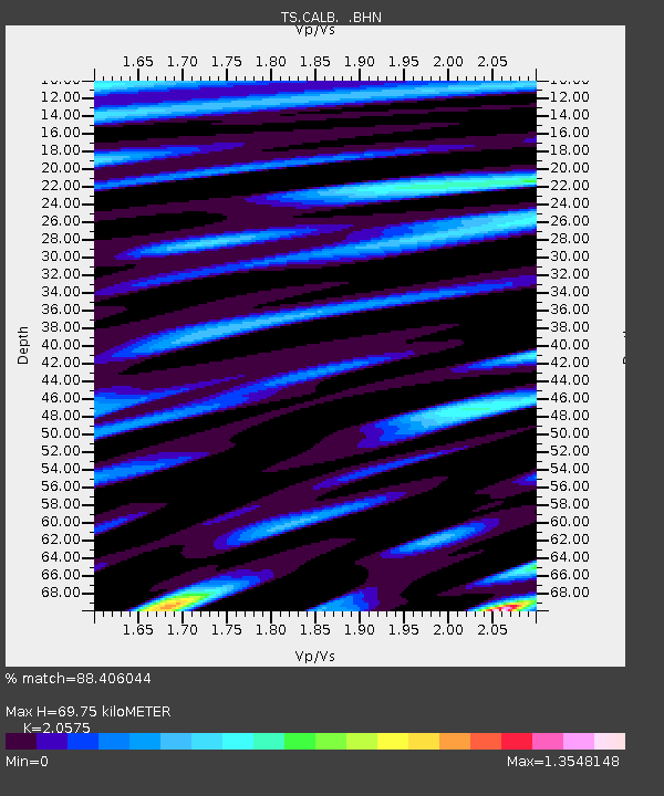
| Estimated Moho Depth: |
69.75 km |
| Estimated Crust Vp/Vs: |
2.06 |
| Assumed Crust Vp: |
6.1 km/s |
| Estimated Crust Vs: |
2.965 km/s |
| Estimated Crust Poisson's Ratio: |
0.35 |
|
| Radial Match: |
88.406044 % |
| Radial Bump: |
400 |
| Transverse Match: |
76.53028 % |
| Transverse Bump: |
400 |
| SOD ConfigId: |
6273 |
| Insert Time: |
2010-02-26 14:02:53.387 +0000 |
| GWidth: |
2.5 |
| Max Bumps: |
400 |
| Tol: |
0.001 |
|

Signal To Noise
| Channel | StoN | STA | LTA |
| TS:CALB: :BHN:19951101T00:46:52.138013Z | 0.98435915 | 3.6393374E-7 | 3.6971642E-7 |
| TS:CALB: :BHE:19951101T00:46:52.138013Z | 1.0327746 | 2.5763538E-7 | 2.4945945E-7 |
| TS:CALB: :BHZ:19951101T00:46:52.138013Z | 3.4194272 | 7.823569E-7 | 2.2879765E-7 |
| Arrivals |
| Ps | 12 SECOND |
| PpPs | 34 SECOND |
| PsPs/PpSs | 47 SECOND |


