You are here: Home > Network List > TA - USArray Transportable Network (new EarthScope stations) Stations List
> Station A21K Barrow, AK, USA > Earthquake Result Viewer
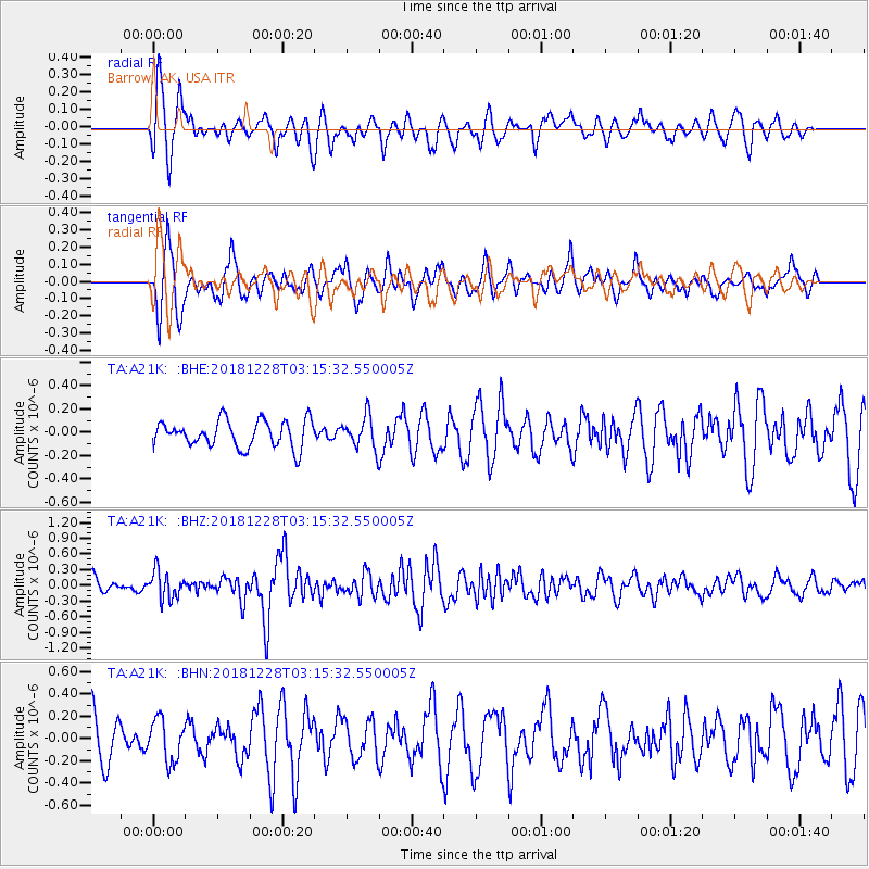
A21K Barrow, AK, USA - Earthquake Result Viewer
*The percent match for this event was below the threshold and hence no stack was calculated.
| Earthquake location: |
Irian Jaya Region, Indonesia |
| Earthquake latitude/longitude: |
-1.5/134.1 |
| Earthquake time(UTC): |
2018/12/28 (362) 03:03:34 GMT |
| Earthquake Depth: |
56 km |
| Earthquake Magnitude: |
5.8 Mww |
| Earthquake Catalog/Contributor: |
NEIC PDE/us |
|
| Network: |
TA USArray Transportable Network (new EarthScope stations) |
| Station: |
A21K Barrow, AK, USA |
| Lat/Lon: |
71.32 N/156.62 W |
| Elevation: |
577 m |
|
| Distance: |
84.9 deg |
| Az: |
17.616 deg |
| Baz: |
249.883 deg |
| Ray Param: |
$rayparam |
*The percent match for this event was below the threshold and hence was not used in the summary stack. |
|
| Radial Match: |
71.92789 % |
| Radial Bump: |
400 |
| Transverse Match: |
77.80048 % |
| Transverse Bump: |
400 |
| SOD ConfigId: |
13570011 |
| Insert Time: |
2019-05-02 04:58:52.097 +0000 |
| GWidth: |
2.5 |
| Max Bumps: |
400 |
| Tol: |
0.001 |
|
Signal To Noise
| Channel | StoN | STA | LTA |
| TA:A21K: :BHZ:20181228T03:15:32.550005Z | 1.6821289 | 2.6429547E-7 | 1.5711963E-7 |
| TA:A21K: :BHN:20181228T03:15:32.550005Z | 0.9592858 | 1.8504758E-7 | 1.9290141E-7 |
| TA:A21K: :BHE:20181228T03:15:32.550005Z | 1.1289225 | 1.2954057E-7 | 1.1474709E-7 |
| Arrivals |
| Ps | |
| PpPs | |
| PsPs/PpSs | |


