You are here: Home > Network List > TA - USArray Transportable Network (new EarthScope stations) Stations List
> Station B18K Kokolik River, AK, USA > Earthquake Result Viewer
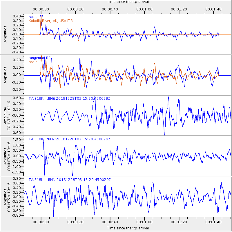
B18K Kokolik River, AK, USA - Earthquake Result Viewer
*The percent match for this event was below the threshold and hence no stack was calculated.
| Earthquake location: |
Irian Jaya Region, Indonesia |
| Earthquake latitude/longitude: |
-1.5/134.1 |
| Earthquake time(UTC): |
2018/12/28 (362) 03:03:34 GMT |
| Earthquake Depth: |
56 km |
| Earthquake Magnitude: |
5.8 Mww |
| Earthquake Catalog/Contributor: |
NEIC PDE/us |
|
| Network: |
TA USArray Transportable Network (new EarthScope stations) |
| Station: |
B18K Kokolik River, AK, USA |
| Lat/Lon: |
69.36 N/161.80 W |
| Elevation: |
222 m |
|
| Distance: |
82.5 deg |
| Az: |
18.768 deg |
| Baz: |
245.13 deg |
| Ray Param: |
$rayparam |
*The percent match for this event was below the threshold and hence was not used in the summary stack. |
|
| Radial Match: |
69.453804 % |
| Radial Bump: |
400 |
| Transverse Match: |
60.82075 % |
| Transverse Bump: |
400 |
| SOD ConfigId: |
13570011 |
| Insert Time: |
2019-05-02 04:58:52.904 +0000 |
| GWidth: |
2.5 |
| Max Bumps: |
400 |
| Tol: |
0.001 |
|
Signal To Noise
| Channel | StoN | STA | LTA |
| TA:B18K: :BHZ:20181228T03:15:20.450029Z | 3.8659027 | 6.1749444E-7 | 1.5972839E-7 |
| TA:B18K: :BHN:20181228T03:15:20.450029Z | 0.98248947 | 1.9098906E-7 | 1.9439298E-7 |
| TA:B18K: :BHE:20181228T03:15:20.450029Z | 3.0338526 | 3.536797E-7 | 1.16577745E-7 |
| Arrivals |
| Ps | |
| PpPs | |
| PsPs/PpSs | |


