You are here: Home > Network List > TA - USArray Transportable Network (new EarthScope stations) Stations List
> Station C16K Lisburne Hills, AK, USA > Earthquake Result Viewer
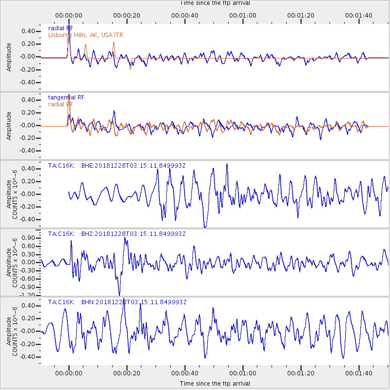
C16K Lisburne Hills, AK, USA - Earthquake Result Viewer
*The percent match for this event was below the threshold and hence no stack was calculated.
| Earthquake location: |
Irian Jaya Region, Indonesia |
| Earthquake latitude/longitude: |
-1.5/134.1 |
| Earthquake time(UTC): |
2018/12/28 (362) 03:03:34 GMT |
| Earthquake Depth: |
56 km |
| Earthquake Magnitude: |
5.8 Mww |
| Earthquake Catalog/Contributor: |
NEIC PDE/us |
|
| Network: |
TA USArray Transportable Network (new EarthScope stations) |
| Station: |
C16K Lisburne Hills, AK, USA |
| Lat/Lon: |
68.27 N/165.34 W |
| Elevation: |
102 m |
|
| Distance: |
80.9 deg |
| Az: |
19.178 deg |
| Baz: |
241.89 deg |
| Ray Param: |
$rayparam |
*The percent match for this event was below the threshold and hence was not used in the summary stack. |
|
| Radial Match: |
59.567383 % |
| Radial Bump: |
400 |
| Transverse Match: |
52.20242 % |
| Transverse Bump: |
400 |
| SOD ConfigId: |
13570011 |
| Insert Time: |
2019-05-02 04:58:54.143 +0000 |
| GWidth: |
2.5 |
| Max Bumps: |
400 |
| Tol: |
0.001 |
|
Signal To Noise
| Channel | StoN | STA | LTA |
| TA:C16K: :BHZ:20181228T03:15:11.849993Z | 2.9469738 | 3.4102575E-7 | 1.1572065E-7 |
| TA:C16K: :BHN:20181228T03:15:11.849993Z | 1.5027696 | 2.0912174E-7 | 1.3915755E-7 |
| TA:C16K: :BHE:20181228T03:15:11.849993Z | 2.8102372 | 2.2917092E-7 | 8.1548606E-8 |
| Arrivals |
| Ps | |
| PpPs | |
| PsPs/PpSs | |


