You are here: Home > Network List > TA - USArray Transportable Network (new EarthScope stations) Stations List
> Station F16A Kennard Place, Willow Creek, MT, USA > Earthquake Result Viewer
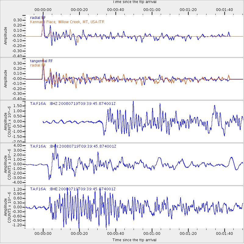
F16A Kennard Place, Willow Creek, MT, USA - Earthquake Result Viewer
*The percent match for this event was below the threshold and hence no stack was calculated.
| Earthquake location: |
Santa Cruz Islands Region |
| Earthquake latitude/longitude: |
-11.0/164.5 |
| Earthquake time(UTC): |
2008/07/19 (201) 09:27:01 GMT |
| Earthquake Depth: |
11 km |
| Earthquake Magnitude: |
6.1 MB, 6.4 MS, 6.6 MW, 6.6 MW |
| Earthquake Catalog/Contributor: |
WHDF/NEIC |
|
| Network: |
TA USArray Transportable Network (new EarthScope stations) |
| Station: |
F16A Kennard Place, Willow Creek, MT, USA |
| Lat/Lon: |
45.78 N/111.63 W |
| Elevation: |
1350 m |
|
| Distance: |
93.6 deg |
| Az: |
44.199 deg |
| Baz: |
257.976 deg |
| Ray Param: |
$rayparam |
*The percent match for this event was below the threshold and hence was not used in the summary stack. |
|
| Radial Match: |
93.75292 % |
| Radial Bump: |
400 |
| Transverse Match: |
90.15152 % |
| Transverse Bump: |
400 |
| SOD ConfigId: |
2658 |
| Insert Time: |
2010-03-06 19:00:33.130 +0000 |
| GWidth: |
2.5 |
| Max Bumps: |
400 |
| Tol: |
0.001 |
|
Signal To Noise
| Channel | StoN | STA | LTA |
| TA:F16A: :BHN:20080719T09:39:45.874001Z | 21.027128 | 1.3454886E-6 | 6.3988224E-8 |
| TA:F16A: :BHE:20080719T09:39:45.874001Z | 3.2231894 | 2.0500275E-7 | 6.360246E-8 |
| TA:F16A: :BHZ:20080719T09:39:45.874001Z | 6.03121 | 5.009409E-7 | 8.305812E-8 |
| Arrivals |
| Ps | |
| PpPs | |
| PsPs/PpSs | |


