You are here: Home > Network List > TA - USArray Transportable Network (new EarthScope stations) Stations List
> Station J20K Nowitna River, AK, USA > Earthquake Result Viewer
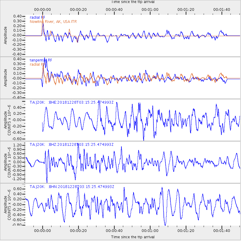
J20K Nowitna River, AK, USA - Earthquake Result Viewer
*The percent match for this event was below the threshold and hence no stack was calculated.
| Earthquake location: |
Irian Jaya Region, Indonesia |
| Earthquake latitude/longitude: |
-1.5/134.1 |
| Earthquake time(UTC): |
2018/12/28 (362) 03:03:34 GMT |
| Earthquake Depth: |
56 km |
| Earthquake Magnitude: |
5.8 Mww |
| Earthquake Catalog/Contributor: |
NEIC PDE/us |
|
| Network: |
TA USArray Transportable Network (new EarthScope stations) |
| Station: |
J20K Nowitna River, AK, USA |
| Lat/Lon: |
64.18 N/154.15 W |
| Elevation: |
314 m |
|
| Distance: |
83.5 deg |
| Az: |
24.755 deg |
| Baz: |
252.897 deg |
| Ray Param: |
$rayparam |
*The percent match for this event was below the threshold and hence was not used in the summary stack. |
|
| Radial Match: |
51.80388 % |
| Radial Bump: |
397 |
| Transverse Match: |
61.849716 % |
| Transverse Bump: |
400 |
| SOD ConfigId: |
13570011 |
| Insert Time: |
2019-05-02 04:59:28.291 +0000 |
| GWidth: |
2.5 |
| Max Bumps: |
400 |
| Tol: |
0.001 |
|
Signal To Noise
| Channel | StoN | STA | LTA |
| TA:J20K: :BHZ:20181228T03:15:25.474993Z | 3.0000541 | 5.3344013E-7 | 1.7781018E-7 |
| TA:J20K: :BHN:20181228T03:15:25.474993Z | 0.8118173 | 1.5767121E-7 | 1.9422008E-7 |
| TA:J20K: :BHE:20181228T03:15:25.474993Z | 1.5867612 | 3.085936E-7 | 1.9448017E-7 |
| Arrivals |
| Ps | |
| PpPs | |
| PsPs/PpSs | |


