You are here: Home > Network List > TM - Thai Seismic Monitoring Network Stations List
> Station NAYO NAYO staion > Earthquake Result Viewer
NAYO NAYO staion - Earthquake Result Viewer
| Earthquake location: |
Irian Jaya Region, Indonesia |
| Earthquake latitude/longitude: |
-1.5/134.1 |
| Earthquake time(UTC): |
2018/12/28 (362) 03:03:34 GMT |
| Earthquake Depth: |
56 km |
| Earthquake Magnitude: |
5.8 Mww |
| Earthquake Catalog/Contributor: |
NEIC PDE/us |
|
| Network: |
TM Thai Seismic Monitoring Network |
| Station: |
NAYO NAYO staion |
| Lat/Lon: |
14.32 N/101.32 E |
| Elevation: |
106 m |
|
| Distance: |
36.0 deg |
| Az: |
296.973 deg |
| Baz: |
113.206 deg |
| Ray Param: |
0.07675368 |
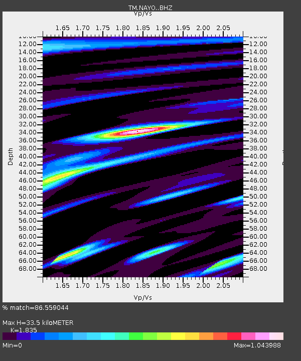
| Estimated Moho Depth: |
33.5 km |
| Estimated Crust Vp/Vs: |
1.84 |
| Assumed Crust Vp: |
6.498 km/s |
| Estimated Crust Vs: |
3.541 km/s |
| Estimated Crust Poisson's Ratio: |
0.29 |
|
| Radial Match: |
86.559044 % |
| Radial Bump: |
400 |
| Transverse Match: |
62.111156 % |
| Transverse Bump: |
400 |
| SOD ConfigId: |
13570011 |
| Insert Time: |
2019-05-02 04:59:53.414 +0000 |
| GWidth: |
2.5 |
| Max Bumps: |
400 |
| Tol: |
0.001 |
|

Signal To Noise
| Channel | StoN | STA | LTA |
| TM:NAYO: :BHZ:20181228T03:10:00.439989Z | 7.861061 | 8.098537E-6 | 1.0302092E-6 |
| TM:NAYO: :BHN:20181228T03:10:00.439989Z | 1.7377595 | 1.6597443E-6 | 9.551059E-7 |
| TM:NAYO: :BHE:20181228T03:10:00.439989Z | 4.6426954 | 4.364173E-6 | 9.400085E-7 |
| Arrivals |
| Ps | 4.6 SECOND |
| PpPs | 14 SECOND |
| PsPs/PpSs | 18 SECOND |


