You are here: Home > Network List > CI - Caltech Regional Seismic Network Stations List
> Station GSC Goldstone, Goldstone Lake, CA, USA > Earthquake Result Viewer
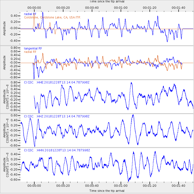
GSC Goldstone, Goldstone Lake, CA, USA - Earthquake Result Viewer
*The percent match for this event was below the threshold and hence no stack was calculated.
| Earthquake location: |
Kuril Islands |
| Earthquake latitude/longitude: |
44.2/148.6 |
| Earthquake time(UTC): |
2018/12/28 (362) 13:03:33 GMT |
| Earthquake Depth: |
49 km |
| Earthquake Magnitude: |
5.5 mb |
| Earthquake Catalog/Contributor: |
NEIC PDE/us |
|
| Network: |
CI Caltech Regional Seismic Network |
| Station: |
GSC Goldstone, Goldstone Lake, CA, USA |
| Lat/Lon: |
35.30 N/116.81 W |
| Elevation: |
1000 m |
|
| Distance: |
69.4 deg |
| Az: |
60.596 deg |
| Baz: |
309.998 deg |
| Ray Param: |
$rayparam |
*The percent match for this event was below the threshold and hence was not used in the summary stack. |
|
| Radial Match: |
50.820736 % |
| Radial Bump: |
400 |
| Transverse Match: |
45.89394 % |
| Transverse Bump: |
400 |
| SOD ConfigId: |
13570011 |
| Insert Time: |
2019-05-02 05:02:27.191 +0000 |
| GWidth: |
2.5 |
| Max Bumps: |
400 |
| Tol: |
0.001 |
|
Signal To Noise
| Channel | StoN | STA | LTA |
| CI:GSC: :HHZ:20181228T13:14:04.787998Z | 1.1455314 | 3.1458563E-7 | 2.7461982E-7 |
| CI:GSC: :HHN:20181228T13:14:04.787998Z | 0.59470975 | 1.3095607E-7 | 2.2020164E-7 |
| CI:GSC: :HHE:20181228T13:14:04.787998Z | 0.4534497 | 1.6876052E-7 | 3.7217032E-7 |
| Arrivals |
| Ps | |
| PpPs | |
| PsPs/PpSs | |


