You are here: Home > Network List > TS - TERRAscope (Southern California Seismic Network) Stations List
> Station CALB Calabasas, California, USA > Earthquake Result Viewer
CALB Calabasas, California, USA - Earthquake Result Viewer

| Earthquake location: |
South Of Fiji Islands |
| Earthquake latitude/longitude: |
-26.8/-177.2 |
| Earthquake time(UTC): |
1996/07/23 (205) 03:32:12 GMT |
| Earthquake Depth: |
33 km |
| Earthquake Magnitude: |
5.8 MB, 6.4 MS, 6.5 UNKNOWN, 6.5 MW |
| Earthquake Catalog/Contributor: |
WHDF/NEIC |
|
| Network: |
TS TERRAscope (Southern California Seismic Network) |
| Station: |
CALB Calabasas, California, USA |
| Lat/Lon: |
34.14 N/118.63 W |
| Elevation: |
0.0 m |
|
| Distance: |
82.2 deg |
| Az: |
45.594 deg |
| Baz: |
230.372 deg |
| Ray Param: |
0.047041744 |
| Estimated Moho Depth: |
38.25 km |
| Estimated Crust Vp/Vs: |
2.07 |
| Assumed Crust Vp: |
6.1 km/s |
| Estimated Crust Vs: |
2.95 km/s |
| Estimated Crust Poisson's Ratio: |
0.35 |
|
| Radial Match: |
81.23264 % |
| Radial Bump: |
400 |
| Transverse Match: |
77.93031 % |
| Transverse Bump: |
400 |
| SOD ConfigId: |
6273 |
| Insert Time: |
2010-02-26 14:02:59.394 +0000 |
| GWidth: |
2.5 |
| Max Bumps: |
400 |
| Tol: |
0.001 |
|
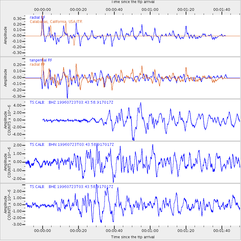
Signal To Noise
| Channel | StoN | STA | LTA |
| TS:CALB: :BHN:19960723T03:43:58.917017Z | 0.92728853 | 2.2292012E-7 | 2.4039994E-7 |
| TS:CALB: :BHE:19960723T03:43:58.917017Z | 0.7832521 | 1.731941E-7 | 2.2112178E-7 |
| TS:CALB: :BHZ:19960723T03:43:58.917017Z | 3.5227861 | 5.38684E-7 | 1.5291418E-7 |
| Arrivals |
| Ps | 6.8 SECOND |
| PpPs | 19 SECOND |
| PsPs/PpSs | 26 SECOND |


