You are here: Home > Network List > IW - Intermountain West Stations List
> Station MOOW Moose Ponds, Wyoming, USA > Earthquake Result Viewer
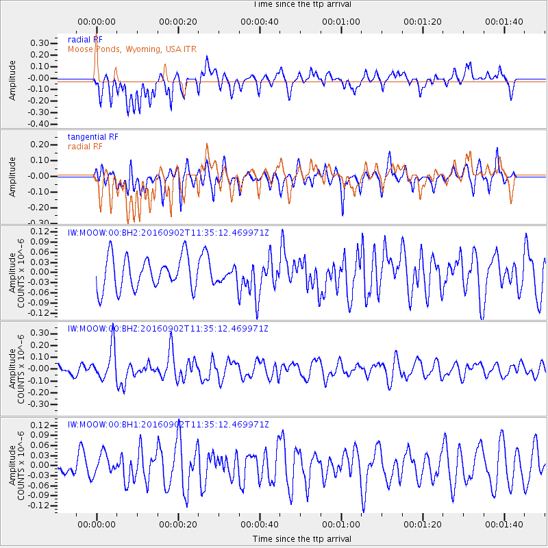
MOOW Moose Ponds, Wyoming, USA - Earthquake Result Viewer
*The percent match for this event was below the threshold and hence no stack was calculated.
| Earthquake location: |
Tonga Islands |
| Earthquake latitude/longitude: |
-19.6/-173.6 |
| Earthquake time(UTC): |
2016/09/02 (246) 11:23:07 GMT |
| Earthquake Depth: |
10 km |
| Earthquake Magnitude: |
5.5 MB |
| Earthquake Catalog/Contributor: |
NEIC PDE/NEIC ALERT |
|
| Network: |
IW Intermountain West |
| Station: |
MOOW Moose Ponds, Wyoming, USA |
| Lat/Lon: |
43.75 N/110.74 W |
| Elevation: |
2128 m |
|
| Distance: |
85.3 deg |
| Az: |
40.326 deg |
| Baz: |
237.345 deg |
| Ray Param: |
$rayparam |
*The percent match for this event was below the threshold and hence was not used in the summary stack. |
|
| Radial Match: |
54.589973 % |
| Radial Bump: |
400 |
| Transverse Match: |
63.708225 % |
| Transverse Bump: |
400 |
| SOD ConfigId: |
1634031 |
| Insert Time: |
2016-09-16 11:26:33.442 +0000 |
| GWidth: |
2.5 |
| Max Bumps: |
400 |
| Tol: |
0.001 |
|
Signal To Noise
| Channel | StoN | STA | LTA |
| IW:MOOW:00:BHZ:20160902T11:35:12.469971Z | 2.0697362 | 1.4225208E-7 | 6.872957E-8 |
| IW:MOOW:00:BH1:20160902T11:35:12.469971Z | 1.2017394 | 3.304415E-8 | 2.7496933E-8 |
| IW:MOOW:00:BH2:20160902T11:35:12.469971Z | 0.4848737 | 2.3198277E-8 | 4.7843955E-8 |
| Arrivals |
| Ps | |
| PpPs | |
| PsPs/PpSs | |


