You are here: Home > Network List > TA - USArray Transportable Network (new EarthScope stations) Stations List
> Station D23K Nanushuk River, AK USA > Earthquake Result Viewer
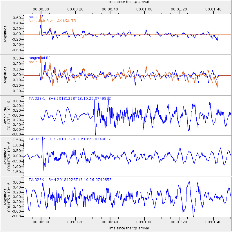
D23K Nanushuk River, AK USA - Earthquake Result Viewer
*The percent match for this event was below the threshold and hence no stack was calculated.
| Earthquake location: |
Kuril Islands |
| Earthquake latitude/longitude: |
44.2/148.6 |
| Earthquake time(UTC): |
2018/12/28 (362) 13:03:33 GMT |
| Earthquake Depth: |
49 km |
| Earthquake Magnitude: |
5.5 mb |
| Earthquake Catalog/Contributor: |
NEIC PDE/us |
|
| Network: |
TA USArray Transportable Network (new EarthScope stations) |
| Station: |
D23K Nanushuk River, AK USA |
| Lat/Lon: |
68.97 N/150.68 W |
| Elevation: |
406 m |
|
| Distance: |
39.2 deg |
| Az: |
29.882 deg |
| Baz: |
262.999 deg |
| Ray Param: |
$rayparam |
*The percent match for this event was below the threshold and hence was not used in the summary stack. |
|
| Radial Match: |
56.74317 % |
| Radial Bump: |
391 |
| Transverse Match: |
62.09444 % |
| Transverse Bump: |
400 |
| SOD ConfigId: |
13570011 |
| Insert Time: |
2019-05-02 05:07:37.444 +0000 |
| GWidth: |
2.5 |
| Max Bumps: |
400 |
| Tol: |
0.001 |
|
Signal To Noise
| Channel | StoN | STA | LTA |
| TA:D23K: :BHZ:20181228T13:10:26.074985Z | 2.3020995 | 6.308235E-7 | 2.7402095E-7 |
| TA:D23K: :BHN:20181228T13:10:26.074985Z | 0.9792745 | 3.133118E-7 | 3.1994279E-7 |
| TA:D23K: :BHE:20181228T13:10:26.074985Z | 2.0836241 | 3.376485E-7 | 1.6204865E-7 |
| Arrivals |
| Ps | |
| PpPs | |
| PsPs/PpSs | |


