You are here: Home > Network List > TA - USArray Transportable Network (new EarthScope stations) Stations List
> Station D25K Kavik River, AK, USA > Earthquake Result Viewer
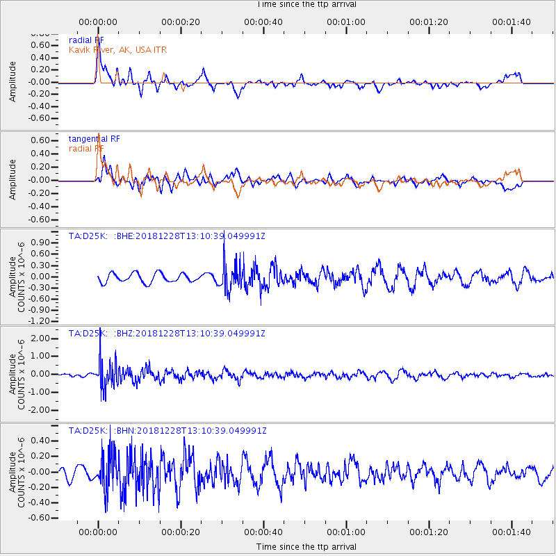
D25K Kavik River, AK, USA - Earthquake Result Viewer
*The percent match for this event was below the threshold and hence no stack was calculated.
| Earthquake location: |
Kuril Islands |
| Earthquake latitude/longitude: |
44.2/148.6 |
| Earthquake time(UTC): |
2018/12/28 (362) 13:03:33 GMT |
| Earthquake Depth: |
49 km |
| Earthquake Magnitude: |
5.5 mb |
| Earthquake Catalog/Contributor: |
NEIC PDE/us |
|
| Network: |
TA USArray Transportable Network (new EarthScope stations) |
| Station: |
D25K Kavik River, AK, USA |
| Lat/Lon: |
69.32 N/146.38 W |
| Elevation: |
770 m |
|
| Distance: |
40.8 deg |
| Az: |
29.541 deg |
| Baz: |
266.758 deg |
| Ray Param: |
$rayparam |
*The percent match for this event was below the threshold and hence was not used in the summary stack. |
|
| Radial Match: |
76.33099 % |
| Radial Bump: |
400 |
| Transverse Match: |
69.61597 % |
| Transverse Bump: |
400 |
| SOD ConfigId: |
13570011 |
| Insert Time: |
2019-05-02 05:07:38.282 +0000 |
| GWidth: |
2.5 |
| Max Bumps: |
400 |
| Tol: |
0.001 |
|
Signal To Noise
| Channel | StoN | STA | LTA |
| TA:D25K: :BHZ:20181228T13:10:39.049991Z | 6.9358726 | 7.7011754E-7 | 1.1103398E-7 |
| TA:D25K: :BHN:20181228T13:10:39.049991Z | 1.7846636 | 2.2954814E-7 | 1.2862263E-7 |
| TA:D25K: :BHE:20181228T13:10:39.049991Z | 2.9909396 | 3.6016343E-7 | 1.2041815E-7 |
| Arrivals |
| Ps | |
| PpPs | |
| PsPs/PpSs | |


