You are here: Home > Network List > TA - USArray Transportable Network (new EarthScope stations) Stations List
> Station E18K Tukpahlearik Creek, AK, USA > Earthquake Result Viewer
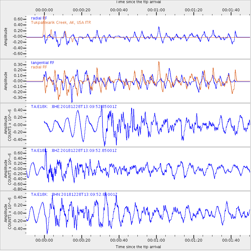
E18K Tukpahlearik Creek, AK, USA - Earthquake Result Viewer
*The percent match for this event was below the threshold and hence no stack was calculated.
| Earthquake location: |
Kuril Islands |
| Earthquake latitude/longitude: |
44.2/148.6 |
| Earthquake time(UTC): |
2018/12/28 (362) 13:03:33 GMT |
| Earthquake Depth: |
49 km |
| Earthquake Magnitude: |
5.5 mb |
| Earthquake Catalog/Contributor: |
NEIC PDE/us |
|
| Network: |
TA USArray Transportable Network (new EarthScope stations) |
| Station: |
E18K Tukpahlearik Creek, AK, USA |
| Lat/Lon: |
67.42 N/160.60 W |
| Elevation: |
297 m |
|
| Distance: |
35.3 deg |
| Az: |
31.214 deg |
| Baz: |
254.852 deg |
| Ray Param: |
$rayparam |
*The percent match for this event was below the threshold and hence was not used in the summary stack. |
|
| Radial Match: |
67.478195 % |
| Radial Bump: |
400 |
| Transverse Match: |
56.48256 % |
| Transverse Bump: |
400 |
| SOD ConfigId: |
13570011 |
| Insert Time: |
2019-05-02 05:07:41.532 +0000 |
| GWidth: |
2.5 |
| Max Bumps: |
400 |
| Tol: |
0.001 |
|
Signal To Noise
| Channel | StoN | STA | LTA |
| TA:E18K: :BHZ:20181228T13:09:52.85001Z | 2.2910783 | 3.1262496E-7 | 1.3645321E-7 |
| TA:E18K: :BHN:20181228T13:09:52.85001Z | 2.4336646 | 2.6170798E-7 | 1.07536586E-7 |
| TA:E18K: :BHE:20181228T13:09:52.85001Z | 1.7019587 | 3.1634136E-7 | 1.85869E-7 |
| Arrivals |
| Ps | |
| PpPs | |
| PsPs/PpSs | |


