You are here: Home > Network List > TA - USArray Transportable Network (new EarthScope stations) Stations List
> Station G15A Dillon, MT, USA > Earthquake Result Viewer
G15A Dillon, MT, USA - Earthquake Result Viewer
| Earthquake location: |
Kuril Islands |
| Earthquake latitude/longitude: |
49.9/156.4 |
| Earthquake time(UTC): |
2008/08/04 (217) 04:42:14 GMT |
| Earthquake Depth: |
77 km |
| Earthquake Magnitude: |
5.6 MB, 5.8 MW, 5.7 MW |
| Earthquake Catalog/Contributor: |
WHDF/NEIC |
|
| Network: |
TA USArray Transportable Network (new EarthScope stations) |
| Station: |
G15A Dillon, MT, USA |
| Lat/Lon: |
45.17 N/112.49 W |
| Elevation: |
1857 m |
|
| Distance: |
58.0 deg |
| Az: |
56.5 deg |
| Baz: |
310.271 deg |
| Ray Param: |
0.06291019 |
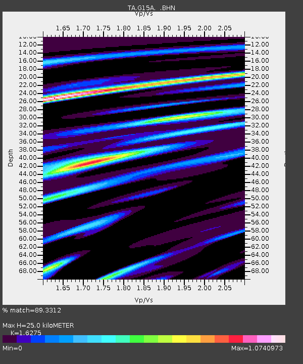
| Estimated Moho Depth: |
25.0 km |
| Estimated Crust Vp/Vs: |
1.63 |
| Assumed Crust Vp: |
6.577 km/s |
| Estimated Crust Vs: |
4.041 km/s |
| Estimated Crust Poisson's Ratio: |
0.20 |
|
| Radial Match: |
89.3312 % |
| Radial Bump: |
400 |
| Transverse Match: |
81.09936 % |
| Transverse Bump: |
400 |
| SOD ConfigId: |
2504 |
| Insert Time: |
2010-03-06 19:01:35.695 +0000 |
| GWidth: |
2.5 |
| Max Bumps: |
400 |
| Tol: |
0.001 |
|

Signal To Noise
| Channel | StoN | STA | LTA |
| TA:G15A: :BHN:20080804T04:51:29.024011Z | 7.71988 | 3.9815782E-7 | 5.157565E-8 |
| TA:G15A: :BHE:20080804T04:51:29.024011Z | 3.0373037 | 1.3150401E-7 | 4.32963E-8 |
| TA:G15A: :BHZ:20080804T04:51:29.024011Z | 3.5796916 | 1.5698923E-7 | 4.385552E-8 |
| Arrivals |
| Ps | 2.5 SECOND |
| PpPs | 9.4 SECOND |
| PsPs/PpSs | 12 SECOND |


