You are here: Home > Network List > TA - USArray Transportable Network (new EarthScope stations) Stations List
> Station I17K Unalakleet, AK, USA > Earthquake Result Viewer
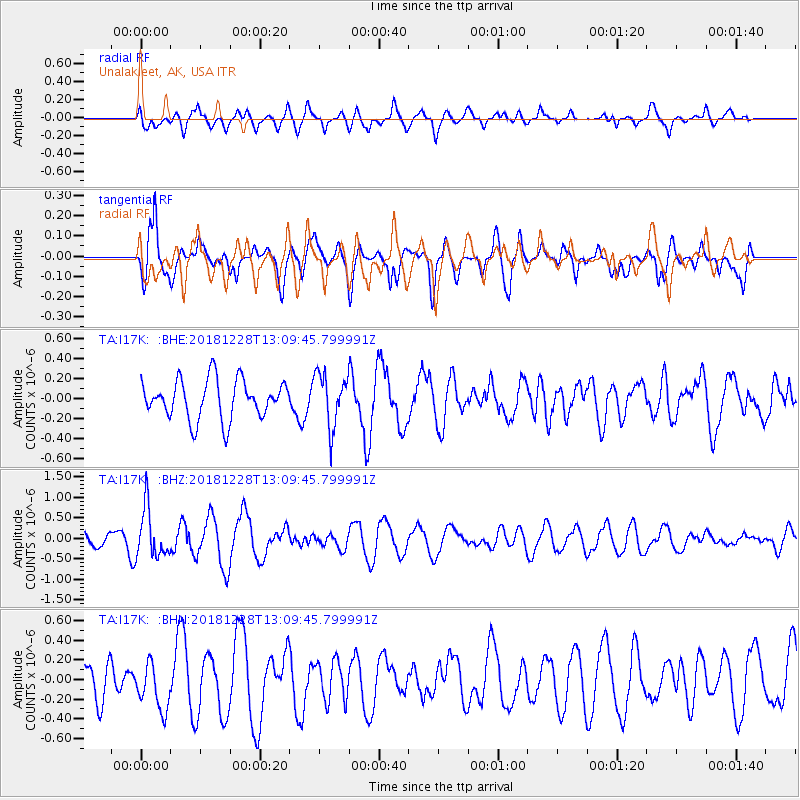
I17K Unalakleet, AK, USA - Earthquake Result Viewer
*The percent match for this event was below the threshold and hence no stack was calculated.
| Earthquake location: |
Kuril Islands |
| Earthquake latitude/longitude: |
44.2/148.6 |
| Earthquake time(UTC): |
2018/12/28 (362) 13:03:33 GMT |
| Earthquake Depth: |
49 km |
| Earthquake Magnitude: |
5.5 mb |
| Earthquake Catalog/Contributor: |
NEIC PDE/us |
|
| Network: |
TA USArray Transportable Network (new EarthScope stations) |
| Station: |
I17K Unalakleet, AK, USA |
| Lat/Lon: |
63.89 N/160.70 W |
| Elevation: |
105 m |
|
| Distance: |
34.5 deg |
| Az: |
37.259 deg |
| Baz: |
259.73 deg |
| Ray Param: |
$rayparam |
*The percent match for this event was below the threshold and hence was not used in the summary stack. |
|
| Radial Match: |
74.01886 % |
| Radial Bump: |
400 |
| Transverse Match: |
62.776634 % |
| Transverse Bump: |
400 |
| SOD ConfigId: |
13570011 |
| Insert Time: |
2019-05-02 05:08:17.118 +0000 |
| GWidth: |
2.5 |
| Max Bumps: |
400 |
| Tol: |
0.001 |
|
Signal To Noise
| Channel | StoN | STA | LTA |
| TA:I17K: :BHZ:20181228T13:09:45.799991Z | 2.9517038 | 5.9407057E-7 | 2.012636E-7 |
| TA:I17K: :BHN:20181228T13:09:45.799991Z | 1.4376284 | 2.41444E-7 | 1.6794606E-7 |
| TA:I17K: :BHE:20181228T13:09:45.799991Z | 1.3557351 | 2.6540346E-7 | 1.9576352E-7 |
| Arrivals |
| Ps | |
| PpPs | |
| PsPs/PpSs | |


