You are here: Home > Network List > TA - USArray Transportable Network (new EarthScope stations) Stations List
> Station I30M Mount Dempster, Yukon, CAN > Earthquake Result Viewer
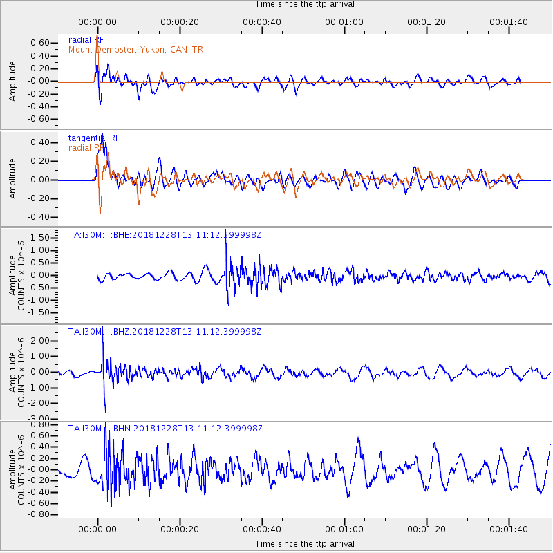
I30M Mount Dempster, Yukon, CAN - Earthquake Result Viewer
*The percent match for this event was below the threshold and hence no stack was calculated.
| Earthquake location: |
Kuril Islands |
| Earthquake latitude/longitude: |
44.2/148.6 |
| Earthquake time(UTC): |
2018/12/28 (362) 13:03:33 GMT |
| Earthquake Depth: |
49 km |
| Earthquake Magnitude: |
5.5 mb |
| Earthquake Catalog/Contributor: |
NEIC PDE/us |
|
| Network: |
TA USArray Transportable Network (new EarthScope stations) |
| Station: |
I30M Mount Dempster, Yukon, CAN |
| Lat/Lon: |
65.22 N/136.38 W |
| Elevation: |
1399 m |
|
| Distance: |
44.9 deg |
| Az: |
35.222 deg |
| Baz: |
280.15 deg |
| Ray Param: |
$rayparam |
*The percent match for this event was below the threshold and hence was not used in the summary stack. |
|
| Radial Match: |
61.70272 % |
| Radial Bump: |
400 |
| Transverse Match: |
75.473976 % |
| Transverse Bump: |
400 |
| SOD ConfigId: |
13570011 |
| Insert Time: |
2019-05-02 05:08:21.102 +0000 |
| GWidth: |
2.5 |
| Max Bumps: |
400 |
| Tol: |
0.001 |
|
Signal To Noise
| Channel | StoN | STA | LTA |
| TA:I30M: :BHZ:20181228T13:11:12.399998Z | 4.495945 | 8.7309166E-7 | 1.9419537E-7 |
| TA:I30M: :BHN:20181228T13:11:12.399998Z | 3.4290287 | 3.4195722E-7 | 9.972422E-8 |
| TA:I30M: :BHE:20181228T13:11:12.399998Z | 4.0762286 | 5.1941714E-7 | 1.2742592E-7 |
| Arrivals |
| Ps | |
| PpPs | |
| PsPs/PpSs | |


