You are here: Home > Network List > TA - USArray Transportable Network (new EarthScope stations) Stations List
> Station G15A Dillon, MT, USA > Earthquake Result Viewer
G15A Dillon, MT, USA - Earthquake Result Viewer
| Earthquake location: |
Sakhalin, Russia |
| Earthquake latitude/longitude: |
47.1/141.8 |
| Earthquake time(UTC): |
2007/08/02 (214) 02:37:42 GMT |
| Earthquake Depth: |
5.0 km |
| Earthquake Magnitude: |
6.2 MS, 5.3 MB, 6.2 MW, 6.2 MW |
| Earthquake Catalog/Contributor: |
WHDF/NEIC |
|
| Network: |
TA USArray Transportable Network (new EarthScope stations) |
| Station: |
G15A Dillon, MT, USA |
| Lat/Lon: |
45.17 N/112.49 W |
| Elevation: |
1857 m |
|
| Distance: |
67.3 deg |
| Az: |
47.562 deg |
| Baz: |
314.562 deg |
| Ray Param: |
0.057036918 |
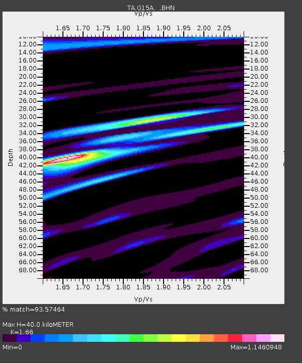
| Estimated Moho Depth: |
40.0 km |
| Estimated Crust Vp/Vs: |
1.66 |
| Assumed Crust Vp: |
6.577 km/s |
| Estimated Crust Vs: |
3.962 km/s |
| Estimated Crust Poisson's Ratio: |
0.22 |
|
| Radial Match: |
93.57464 % |
| Radial Bump: |
400 |
| Transverse Match: |
82.10681 % |
| Transverse Bump: |
400 |
| SOD ConfigId: |
2564 |
| Insert Time: |
2010-03-06 19:02:24.524 +0000 |
| GWidth: |
2.5 |
| Max Bumps: |
400 |
| Tol: |
0.001 |
|

Signal To Noise
| Channel | StoN | STA | LTA |
| TA:G15A: :BHN:20070802T02:48:07.02502Z | 1.3882391 | 5.3309094E-8 | 3.840051E-8 |
| TA:G15A: :BHE:20070802T02:48:07.02502Z | 1.7155663 | 6.319385E-8 | 3.6835562E-8 |
| TA:G15A: :BHZ:20070802T02:48:07.02502Z | 1.9305904 | 7.6745465E-8 | 3.9752333E-8 |
| Arrivals |
| Ps | 4.2 SECOND |
| PpPs | 15 SECOND |
| PsPs/PpSs | 20 SECOND |


