You are here: Home > Network List > TA - USArray Transportable Network (new EarthScope stations) Stations List
> Station G15A Dillon, MT, USA > Earthquake Result Viewer
G15A Dillon, MT, USA - Earthquake Result Viewer
| Earthquake location: |
North Of Svalbard |
| Earthquake latitude/longitude: |
80.3/-1.9 |
| Earthquake time(UTC): |
2009/03/06 (065) 10:50:29 GMT |
| Earthquake Depth: |
9.0 km |
| Earthquake Magnitude: |
6.6 MB, 6.5 MS, 6.5 MW, 6.4 MW |
| Earthquake Catalog/Contributor: |
WHDF/NEIC |
|
| Network: |
TA USArray Transportable Network (new EarthScope stations) |
| Station: |
G15A Dillon, MT, USA |
| Lat/Lon: |
45.17 N/112.49 W |
| Elevation: |
1857 m |
|
| Distance: |
49.1 deg |
| Az: |
298.888 deg |
| Baz: |
12.086 deg |
| Ray Param: |
0.06890553 |
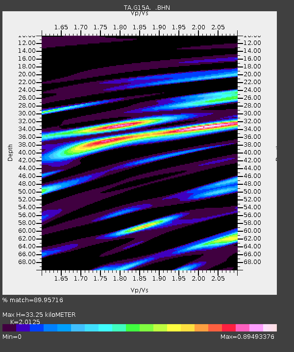
| Estimated Moho Depth: |
33.25 km |
| Estimated Crust Vp/Vs: |
2.01 |
| Assumed Crust Vp: |
6.577 km/s |
| Estimated Crust Vs: |
3.268 km/s |
| Estimated Crust Poisson's Ratio: |
0.34 |
|
| Radial Match: |
89.95716 % |
| Radial Bump: |
400 |
| Transverse Match: |
83.991455 % |
| Transverse Bump: |
400 |
| SOD ConfigId: |
2658 |
| Insert Time: |
2010-03-06 19:03:02.906 +0000 |
| GWidth: |
2.5 |
| Max Bumps: |
400 |
| Tol: |
0.001 |
|

Signal To Noise
| Channel | StoN | STA | LTA |
| TA:G15A: :BHN:20090306T10:58:46.300015Z | 42.769955 | 4.1798926E-6 | 9.772965E-8 |
| TA:G15A: :BHE:20090306T10:58:46.300015Z | 15.925829 | 2.5934532E-6 | 1.6284572E-7 |
| TA:G15A: :BHZ:20090306T10:58:46.300015Z | 3.0766537 | 5.2630173E-7 | 1.7106304E-7 |
| Arrivals |
| Ps | 5.4 SECOND |
| PpPs | 14 SECOND |
| PsPs/PpSs | 20 SECOND |


