You are here: Home > Network List > TA - USArray Transportable Network (new EarthScope stations) Stations List
> Station G15A Dillon, MT, USA > Earthquake Result Viewer
G15A Dillon, MT, USA - Earthquake Result Viewer

| Earthquake location: |
Loyalty Islands |
| Earthquake latitude/longitude: |
-20.1/168.9 |
| Earthquake time(UTC): |
2008/04/09 (100) 12:46:12 GMT |
| Earthquake Depth: |
33 km |
| Earthquake Magnitude: |
6.3 MB, 7.3 MS, 7.3 MW, 7.3 MW |
| Earthquake Catalog/Contributor: |
WHDF/NEIC |
|
| Network: |
TA USArray Transportable Network (new EarthScope stations) |
| Station: |
G15A Dillon, MT, USA |
| Lat/Lon: |
45.17 N/112.49 W |
| Elevation: |
1857 m |
|
| Distance: |
96.3 deg |
| Az: |
44.247 deg |
| Baz: |
247.993 deg |
| Ray Param: |
0.040536508 |
| Estimated Moho Depth: |
27.75 km |
| Estimated Crust Vp/Vs: |
1.74 |
| Assumed Crust Vp: |
6.577 km/s |
| Estimated Crust Vs: |
3.785 km/s |
| Estimated Crust Poisson's Ratio: |
0.25 |
|
| Radial Match: |
95.674 % |
| Radial Bump: |
314 |
| Transverse Match: |
79.44799 % |
| Transverse Bump: |
400 |
| SOD ConfigId: |
2504 |
| Insert Time: |
2010-03-06 19:03:21.436 +0000 |
| GWidth: |
2.5 |
| Max Bumps: |
400 |
| Tol: |
0.001 |
|
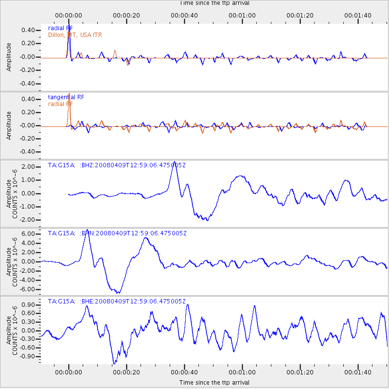
Signal To Noise
| Channel | StoN | STA | LTA |
| TA:G15A: :BHN:20080409T12:59:06.475005Z | 4.20103 | 9.1899835E-7 | 2.1875552E-7 |
| TA:G15A: :BHE:20080409T12:59:06.475005Z | 2.060141 | 2.5788694E-7 | 1.2517927E-7 |
| TA:G15A: :BHZ:20080409T12:59:06.475005Z | 2.4903436 | 2.5587457E-7 | 1.0274669E-7 |
| Arrivals |
| Ps | 3.2 SECOND |
| PpPs | 11 SECOND |
| PsPs/PpSs | 14 SECOND |


