You are here: Home > Network List > TA - USArray Transportable Network (new EarthScope stations) Stations List
> Station B18K Kokolik River, AK, USA > Earthquake Result Viewer
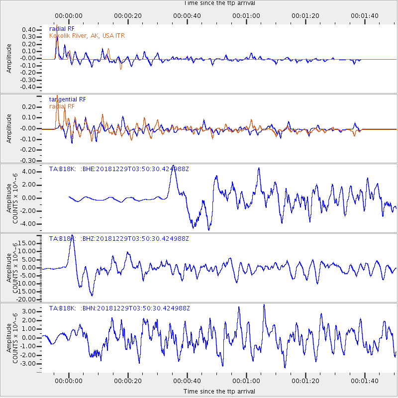
B18K Kokolik River, AK, USA - Earthquake Result Viewer
*The percent match for this event was below the threshold and hence no stack was calculated.
| Earthquake location: |
Mindanao, Philippines |
| Earthquake latitude/longitude: |
5.8/126.9 |
| Earthquake time(UTC): |
2018/12/29 (363) 03:39:12 GMT |
| Earthquake Depth: |
49 km |
| Earthquake Magnitude: |
7.2 Mi |
| Earthquake Catalog/Contributor: |
NEIC PDE/at |
|
| Network: |
TA USArray Transportable Network (new EarthScope stations) |
| Station: |
B18K Kokolik River, AK, USA |
| Lat/Lon: |
69.36 N/161.80 W |
| Elevation: |
222 m |
|
| Distance: |
78.1 deg |
| Az: |
20.073 deg |
| Baz: |
254.423 deg |
| Ray Param: |
$rayparam |
*The percent match for this event was below the threshold and hence was not used in the summary stack. |
|
| Radial Match: |
92.274925 % |
| Radial Bump: |
400 |
| Transverse Match: |
86.2306 % |
| Transverse Bump: |
400 |
| SOD ConfigId: |
13570011 |
| Insert Time: |
2019-05-02 05:15:35.386 +0000 |
| GWidth: |
2.5 |
| Max Bumps: |
400 |
| Tol: |
0.001 |
|
Signal To Noise
| Channel | StoN | STA | LTA |
| TA:B18K: :BHZ:20181229T03:50:30.424988Z | 30.303642 | 1.1440044E-5 | 3.775138E-7 |
| TA:B18K: :BHN:20181229T03:50:30.424988Z | 2.926305 | 8.6140494E-7 | 2.943661E-7 |
| TA:B18K: :BHE:20181229T03:50:30.424988Z | 14.147135 | 2.8112902E-6 | 1.9871798E-7 |
| Arrivals |
| Ps | |
| PpPs | |
| PsPs/PpSs | |


