You are here: Home > Network List > TA - USArray Transportable Network (new EarthScope stations) Stations List
> Station C16K Lisburne Hills, AK, USA > Earthquake Result Viewer
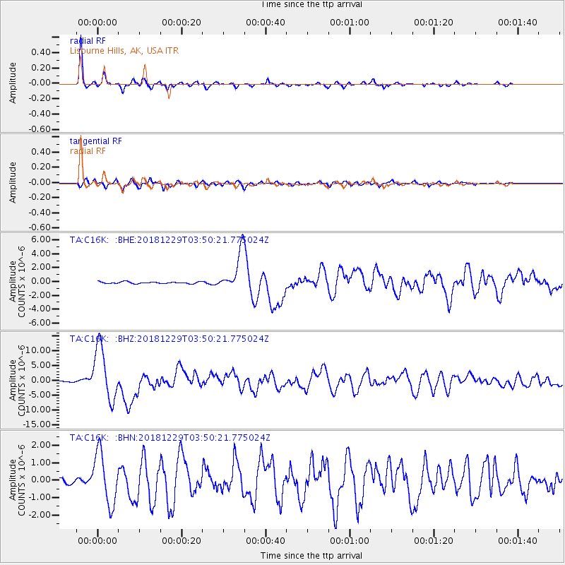
C16K Lisburne Hills, AK, USA - Earthquake Result Viewer
*The percent match for this event was below the threshold and hence no stack was calculated.
| Earthquake location: |
Mindanao, Philippines |
| Earthquake latitude/longitude: |
5.8/126.9 |
| Earthquake time(UTC): |
2018/12/29 (363) 03:39:12 GMT |
| Earthquake Depth: |
49 km |
| Earthquake Magnitude: |
7.2 Mi |
| Earthquake Catalog/Contributor: |
NEIC PDE/at |
|
| Network: |
TA USArray Transportable Network (new EarthScope stations) |
| Station: |
C16K Lisburne Hills, AK, USA |
| Lat/Lon: |
68.27 N/165.34 W |
| Elevation: |
102 m |
|
| Distance: |
76.5 deg |
| Az: |
20.756 deg |
| Baz: |
251.274 deg |
| Ray Param: |
$rayparam |
*The percent match for this event was below the threshold and hence was not used in the summary stack. |
|
| Radial Match: |
95.28342 % |
| Radial Bump: |
297 |
| Transverse Match: |
88.857666 % |
| Transverse Bump: |
400 |
| SOD ConfigId: |
13570011 |
| Insert Time: |
2019-05-02 05:15:39.517 +0000 |
| GWidth: |
2.5 |
| Max Bumps: |
400 |
| Tol: |
0.001 |
|
Signal To Noise
| Channel | StoN | STA | LTA |
| TA:C16K: :BHZ:20181229T03:50:21.775024Z | 48.889114 | 9.172769E-6 | 1.8762395E-7 |
| TA:C16K: :BHN:20181229T03:50:21.775024Z | 7.4564905 | 1.5108681E-6 | 2.0262456E-7 |
| TA:C16K: :BHE:20181229T03:50:21.775024Z | 28.067244 | 3.8252674E-6 | 1.3628939E-7 |
| Arrivals |
| Ps | |
| PpPs | |
| PsPs/PpSs | |


