You are here: Home > Network List > TA - USArray Transportable Network (new EarthScope stations) Stations List
> Station G15A Dillon, MT, USA > Earthquake Result Viewer
G15A Dillon, MT, USA - Earthquake Result Viewer
| Earthquake location: |
Iceland |
| Earthquake latitude/longitude: |
64.0/-21.0 |
| Earthquake time(UTC): |
2008/05/29 (150) 15:46:00 GMT |
| Earthquake Depth: |
10 km |
| Earthquake Magnitude: |
6.0 MB, 6.2 MS, 6.3 MW, 6.2 MW |
| Earthquake Catalog/Contributor: |
WHDF/NEIC |
|
| Network: |
TA USArray Transportable Network (new EarthScope stations) |
| Station: |
G15A Dillon, MT, USA |
| Lat/Lon: |
45.17 N/112.49 W |
| Elevation: |
1857 m |
|
| Distance: |
51.2 deg |
| Az: |
294.871 deg |
| Baz: |
34.414 deg |
| Ray Param: |
0.06755436 |
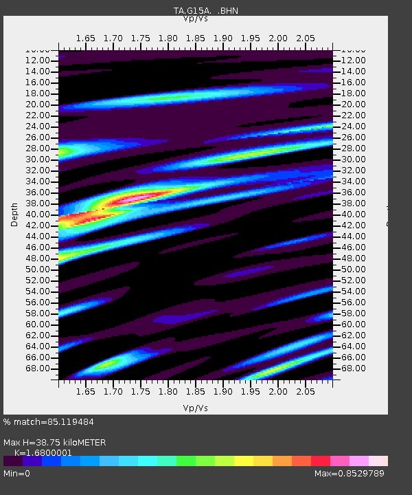
| Estimated Moho Depth: |
38.75 km |
| Estimated Crust Vp/Vs: |
1.68 |
| Assumed Crust Vp: |
6.577 km/s |
| Estimated Crust Vs: |
3.915 km/s |
| Estimated Crust Poisson's Ratio: |
0.23 |
|
| Radial Match: |
85.119484 % |
| Radial Bump: |
300 |
| Transverse Match: |
69.72801 % |
| Transverse Bump: |
400 |
| SOD ConfigId: |
2504 |
| Insert Time: |
2010-03-06 19:03:32.620 +0000 |
| GWidth: |
2.5 |
| Max Bumps: |
400 |
| Tol: |
0.001 |
|

Signal To Noise
| Channel | StoN | STA | LTA |
| TA:G15A: :BHN:20080529T15:54:33.000029Z | 6.7738166 | 4.90434E-7 | 7.240143E-8 |
| TA:G15A: :BHE:20080529T15:54:33.000029Z | 3.226973 | 2.6996847E-7 | 8.365996E-8 |
| TA:G15A: :BHZ:20080529T15:54:33.000029Z | 2.2154434 | 1.545789E-7 | 6.977335E-8 |
| Arrivals |
| Ps | 4.3 SECOND |
| PpPs | 15 SECOND |
| PsPs/PpSs | 19 SECOND |


