You are here: Home > Network List > TA - USArray Transportable Network (new EarthScope stations) Stations List
> Station D25K Kavik River, AK, USA > Earthquake Result Viewer
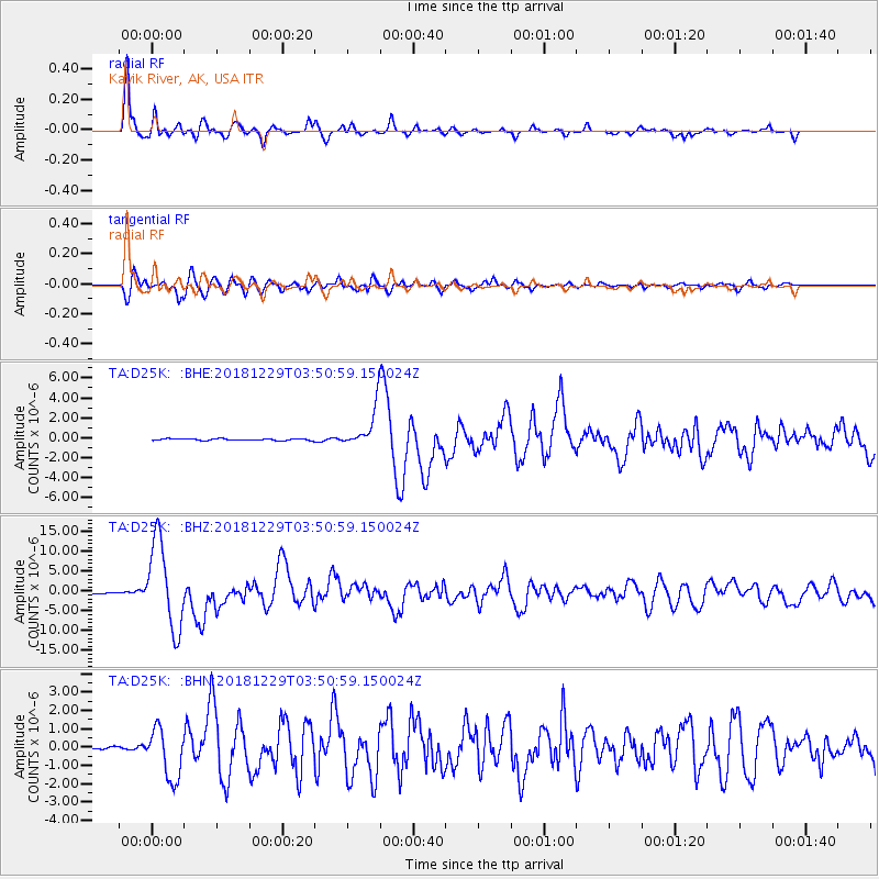
D25K Kavik River, AK, USA - Earthquake Result Viewer
*The percent match for this event was below the threshold and hence no stack was calculated.
| Earthquake location: |
Mindanao, Philippines |
| Earthquake latitude/longitude: |
5.8/126.9 |
| Earthquake time(UTC): |
2018/12/29 (363) 03:39:12 GMT |
| Earthquake Depth: |
49 km |
| Earthquake Magnitude: |
7.2 Mi |
| Earthquake Catalog/Contributor: |
NEIC PDE/at |
|
| Network: |
TA USArray Transportable Network (new EarthScope stations) |
| Station: |
D25K Kavik River, AK, USA |
| Lat/Lon: |
69.32 N/146.38 W |
| Elevation: |
770 m |
|
| Distance: |
83.5 deg |
| Az: |
20.913 deg |
| Baz: |
268.992 deg |
| Ray Param: |
$rayparam |
*The percent match for this event was below the threshold and hence was not used in the summary stack. |
|
| Radial Match: |
94.41661 % |
| Radial Bump: |
400 |
| Transverse Match: |
89.88661 % |
| Transverse Bump: |
400 |
| SOD ConfigId: |
13570011 |
| Insert Time: |
2019-05-02 05:15:50.165 +0000 |
| GWidth: |
2.5 |
| Max Bumps: |
400 |
| Tol: |
0.001 |
|
Signal To Noise
| Channel | StoN | STA | LTA |
| TA:D25K: :BHZ:20181229T03:50:59.150024Z | 79.1411 | 1.0957032E-5 | 1.3844932E-7 |
| TA:D25K: :BHN:20181229T03:50:59.150024Z | 11.979031 | 1.3803188E-6 | 1.1522793E-7 |
| TA:D25K: :BHE:20181229T03:50:59.150024Z | 41.559006 | 4.5836946E-6 | 1.10293655E-7 |
| Arrivals |
| Ps | |
| PpPs | |
| PsPs/PpSs | |


