You are here: Home > Network List > TA - USArray Transportable Network (new EarthScope stations) Stations List
> Station F21K Alatna River, AK, USA > Earthquake Result Viewer
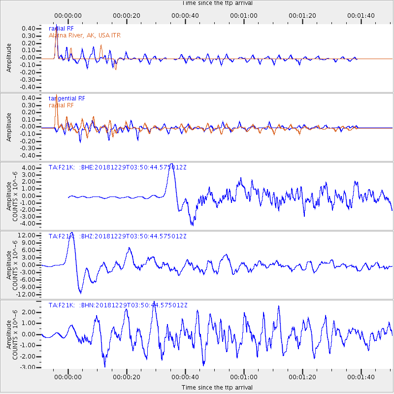
F21K Alatna River, AK, USA - Earthquake Result Viewer
*The percent match for this event was below the threshold and hence no stack was calculated.
| Earthquake location: |
Mindanao, Philippines |
| Earthquake latitude/longitude: |
5.8/126.9 |
| Earthquake time(UTC): |
2018/12/29 (363) 03:39:12 GMT |
| Earthquake Depth: |
49 km |
| Earthquake Magnitude: |
7.2 Mi |
| Earthquake Catalog/Contributor: |
NEIC PDE/at |
|
| Network: |
TA USArray Transportable Network (new EarthScope stations) |
| Station: |
F21K Alatna River, AK, USA |
| Lat/Lon: |
67.22 N/153.48 W |
| Elevation: |
597 m |
|
| Distance: |
80.7 deg |
| Az: |
22.839 deg |
| Baz: |
262.659 deg |
| Ray Param: |
$rayparam |
*The percent match for this event was below the threshold and hence was not used in the summary stack. |
|
| Radial Match: |
92.35752 % |
| Radial Bump: |
400 |
| Transverse Match: |
89.183556 % |
| Transverse Bump: |
400 |
| SOD ConfigId: |
13570011 |
| Insert Time: |
2019-05-02 05:16:07.622 +0000 |
| GWidth: |
2.5 |
| Max Bumps: |
400 |
| Tol: |
0.001 |
|
Signal To Noise
| Channel | StoN | STA | LTA |
| TA:F21K: :BHZ:20181229T03:50:44.575012Z | 64.527504 | 9.289222E-6 | 1.4395756E-7 |
| TA:F21K: :BHN:20181229T03:50:44.575012Z | 4.0241647 | 5.4221647E-7 | 1.3474013E-7 |
| TA:F21K: :BHE:20181229T03:50:44.575012Z | 29.720417 | 2.938202E-6 | 9.886139E-8 |
| Arrivals |
| Ps | |
| PpPs | |
| PsPs/PpSs | |


