You are here: Home > Network List > TA - USArray Transportable Network (new EarthScope stations) Stations List
> Station G15A Dillon, MT, USA > Earthquake Result Viewer
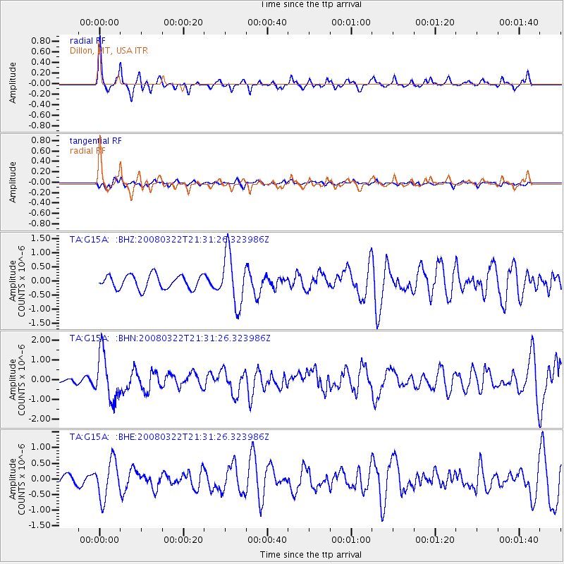
G15A Dillon, MT, USA - Earthquake Result Viewer
*The percent match for this event was below the threshold and hence no stack was calculated.
| Earthquake location: |
Andreanof Islands, Aleutian Is. |
| Earthquake latitude/longitude: |
52.2/-178.7 |
| Earthquake time(UTC): |
2008/03/22 (082) 21:24:11 GMT |
| Earthquake Depth: |
132 km |
| Earthquake Magnitude: |
5.8 MB, 6.2 MW, 6.1 MW |
| Earthquake Catalog/Contributor: |
WHDF/NEIC |
|
| Network: |
TA USArray Transportable Network (new EarthScope stations) |
| Station: |
G15A Dillon, MT, USA |
| Lat/Lon: |
45.17 N/112.49 W |
| Elevation: |
1857 m |
|
| Distance: |
42.9 deg |
| Az: |
71.984 deg |
| Baz: |
304.126 deg |
| Ray Param: |
$rayparam |
*The percent match for this event was below the threshold and hence was not used in the summary stack. |
|
| Radial Match: |
79.78644 % |
| Radial Bump: |
303 |
| Transverse Match: |
59.180237 % |
| Transverse Bump: |
400 |
| SOD ConfigId: |
2504 |
| Insert Time: |
2010-03-06 19:03:56.258 +0000 |
| GWidth: |
2.5 |
| Max Bumps: |
400 |
| Tol: |
0.001 |
|
Signal To Noise
| Channel | StoN | STA | LTA |
| TA:G15A: :BHN:20080322T21:31:26.323986Z | 6.1847296 | 1.1906636E-6 | 1.9251668E-7 |
| TA:G15A: :BHE:20080322T21:31:26.323986Z | 3.9819455 | 6.2086184E-7 | 1.5591922E-7 |
| TA:G15A: :BHZ:20080322T21:31:26.323986Z | 3.8303435 | 9.3464377E-7 | 2.4401044E-7 |
| Arrivals |
| Ps | |
| PpPs | |
| PsPs/PpSs | |


