You are here: Home > Network List > TA - USArray Transportable Network (new EarthScope stations) Stations List
> Station J26L Joseph Creek, AK, USA > Earthquake Result Viewer
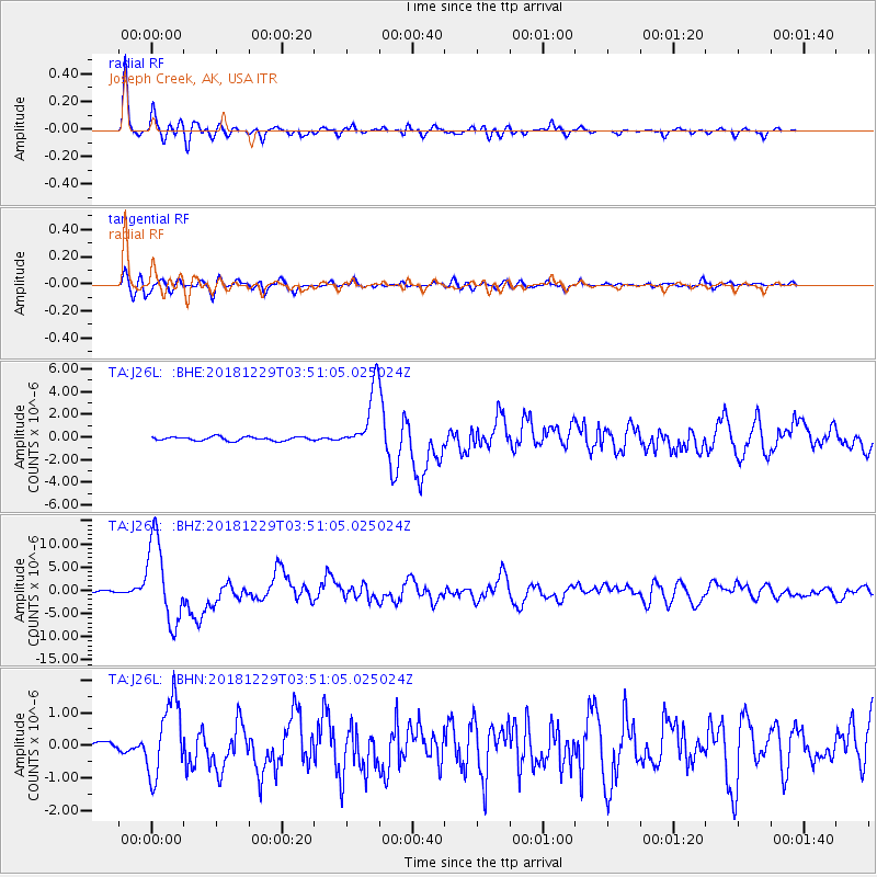
J26L Joseph Creek, AK, USA - Earthquake Result Viewer
*The percent match for this event was below the threshold and hence no stack was calculated.
| Earthquake location: |
Mindanao, Philippines |
| Earthquake latitude/longitude: |
5.8/126.9 |
| Earthquake time(UTC): |
2018/12/29 (363) 03:39:12 GMT |
| Earthquake Depth: |
49 km |
| Earthquake Magnitude: |
7.2 Mi |
| Earthquake Catalog/Contributor: |
NEIC PDE/at |
|
| Network: |
TA USArray Transportable Network (new EarthScope stations) |
| Station: |
J26L Joseph Creek, AK, USA |
| Lat/Lon: |
64.50 N/143.56 W |
| Elevation: |
1144 m |
|
| Distance: |
84.6 deg |
| Az: |
25.77 deg |
| Baz: |
272.084 deg |
| Ray Param: |
$rayparam |
*The percent match for this event was below the threshold and hence was not used in the summary stack. |
|
| Radial Match: |
96.876495 % |
| Radial Bump: |
321 |
| Transverse Match: |
83.68749 % |
| Transverse Bump: |
400 |
| SOD ConfigId: |
13570011 |
| Insert Time: |
2019-05-02 05:16:44.071 +0000 |
| GWidth: |
2.5 |
| Max Bumps: |
400 |
| Tol: |
0.001 |
|
Signal To Noise
| Channel | StoN | STA | LTA |
| TA:J26L: :BHZ:20181229T03:51:05.025024Z | 39.744762 | 8.92037E-6 | 2.2444141E-7 |
| TA:J26L: :BHN:20181229T03:51:05.025024Z | 9.515521 | 1.1571547E-6 | 1.2160707E-7 |
| TA:J26L: :BHE:20181229T03:51:05.025024Z | 21.955046 | 3.6109302E-6 | 1.6446927E-7 |
| Arrivals |
| Ps | |
| PpPs | |
| PsPs/PpSs | |


