You are here: Home > Network List > TA - USArray Transportable Network (new EarthScope stations) Stations List
> Station G15A Dillon, MT, USA > Earthquake Result Viewer
G15A Dillon, MT, USA - Earthquake Result Viewer
*The percent match for this event was below the threshold and hence no stack was calculated.
| Earthquake location: |
South Of Fiji Islands |
| Earthquake latitude/longitude: |
-25.4/-177.6 |
| Earthquake time(UTC): |
2008/09/01 (245) 04:00:39 GMT |
| Earthquake Depth: |
171 km |
| Earthquake Magnitude: |
5.7 MB, 6.0 MW, 6.0 MW |
| Earthquake Catalog/Contributor: |
WHDF/NEIC |
|
| Network: |
TA USArray Transportable Network (new EarthScope stations) |
| Station: |
G15A Dillon, MT, USA |
| Lat/Lon: |
45.17 N/112.49 W |
| Elevation: |
1857 m |
|
| Distance: |
91.9 deg |
| Az: |
39.96 deg |
| Baz: |
235.206 deg |
| Ray Param: |
$rayparam |
*The percent match for this event was below the threshold and hence was not used in the summary stack. |
|
| Radial Match: |
52.795845 % |
| Radial Bump: |
400 |
| Transverse Match: |
66.90935 % |
| Transverse Bump: |
400 |
| SOD ConfigId: |
2504 |
| Insert Time: |
2010-03-06 19:04:27.198 +0000 |
| GWidth: |
2.5 |
| Max Bumps: |
400 |
| Tol: |
0.001 |
|
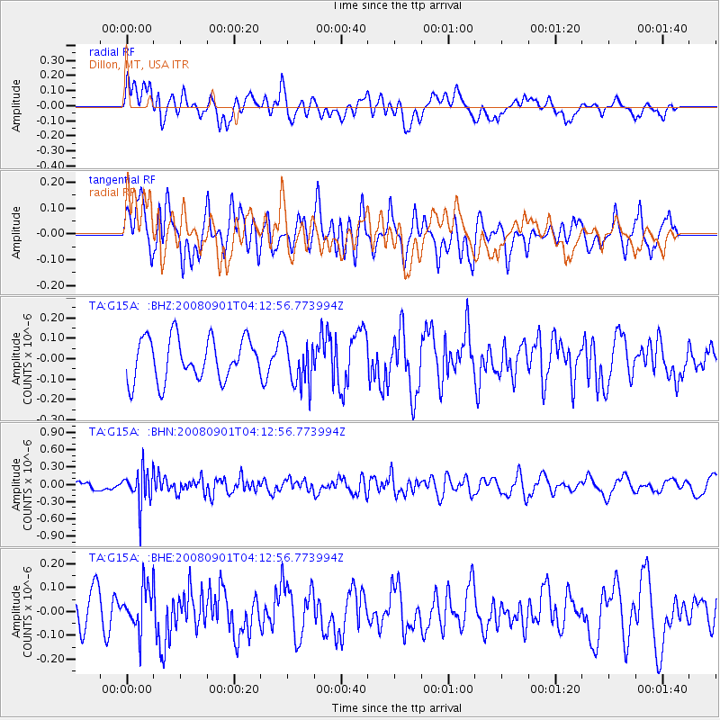
Signal To Noise
| Channel | StoN | STA | LTA |
| TA:G15A: :BHN:20080901T04:12:56.773994Z | 2.7705305 | 2.986366E-7 | 1.077904E-7 |
| TA:G15A: :BHE:20080901T04:12:56.773994Z | 1.0829479 | 8.982888E-8 | 8.2948475E-8 |
| TA:G15A: :BHZ:20080901T04:12:56.773994Z | 1.072773 | 1.1023906E-7 | 1.0276085E-7 |
| Arrivals |
| Ps | |
| PpPs | |
| PsPs/PpSs | |


