You are here: Home > Network List > TS - TERRAscope (Southern California Seismic Network) Stations List
> Station CALB Calabasas, California, USA > Earthquake Result Viewer
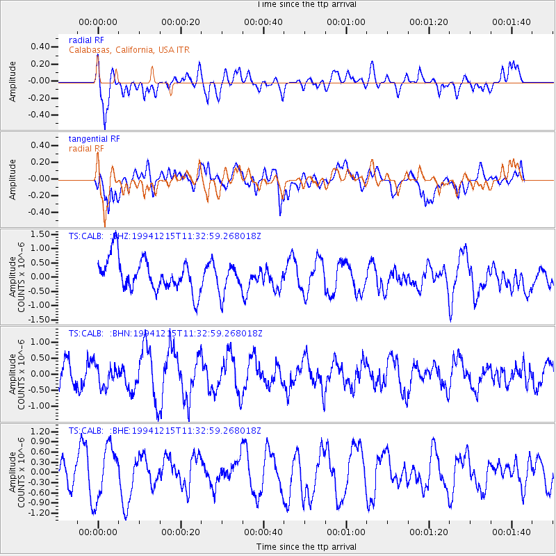
CALB Calabasas, California, USA - Earthquake Result Viewer
*The percent match for this event was below the threshold and hence no stack was calculated.
| Earthquake location: |
Off E. Coast Of N. Island, N.Z. |
| Earthquake latitude/longitude: |
-37.3/177.5 |
| Earthquake time(UTC): |
1994/12/15 (349) 11:20:22 GMT |
| Earthquake Depth: |
33 km |
| Earthquake Magnitude: |
5.7 MB, 6.4 MS, 6.5 UNKNOWN, 6.3 MW |
| Earthquake Catalog/Contributor: |
WHDF/NEIC |
|
| Network: |
TS TERRAscope (Southern California Seismic Network) |
| Station: |
CALB Calabasas, California, USA |
| Lat/Lon: |
34.14 N/118.63 W |
| Elevation: |
0.0 m |
|
| Distance: |
92.6 deg |
| Az: |
48.168 deg |
| Baz: |
225.732 deg |
| Ray Param: |
$rayparam |
*The percent match for this event was below the threshold and hence was not used in the summary stack. |
|
| Radial Match: |
47.87604 % |
| Radial Bump: |
400 |
| Transverse Match: |
63.68718 % |
| Transverse Bump: |
400 |
| SOD ConfigId: |
4480 |
| Insert Time: |
2010-02-26 14:03:08.017 +0000 |
| GWidth: |
2.5 |
| Max Bumps: |
400 |
| Tol: |
0.001 |
|
Signal To Noise
| Channel | StoN | STA | LTA |
| TS:CALB: :BHN:19941215T11:32:59.268018Z | 0.74984866 | 3.2112015E-7 | 4.282466E-7 |
| TS:CALB: :BHE:19941215T11:32:59.268018Z | 1.8084366 | 7.5277416E-7 | 4.1625685E-7 |
| TS:CALB: :BHZ:19941215T11:32:59.268018Z | 0.94362754 | 5.4041374E-7 | 5.726981E-7 |
| Arrivals |
| Ps | |
| PpPs | |
| PsPs/PpSs | |


