You are here: Home > Network List > TA - USArray Transportable Network (new EarthScope stations) Stations List
> Station A36M Sachs Harbour, NT, CAN > Earthquake Result Viewer
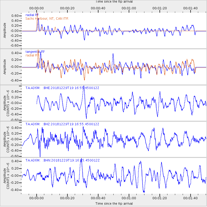
A36M Sachs Harbour, NT, CAN - Earthquake Result Viewer
*The percent match for this event was below the threshold and hence no stack was calculated.
| Earthquake location: |
Hokkaido, Japan Region |
| Earthquake latitude/longitude: |
42.3/143.2 |
| Earthquake time(UTC): |
2018/12/29 (363) 19:08:30 GMT |
| Earthquake Depth: |
58 km |
| Earthquake Magnitude: |
5.5 mb |
| Earthquake Catalog/Contributor: |
NEIC PDE/us |
|
| Network: |
TA USArray Transportable Network (new EarthScope stations) |
| Station: |
A36M Sachs Harbour, NT, CAN |
| Lat/Lon: |
71.99 N/125.25 W |
| Elevation: |
32 m |
|
| Distance: |
50.9 deg |
| Az: |
23.627 deg |
| Baz: |
287.033 deg |
| Ray Param: |
$rayparam |
*The percent match for this event was below the threshold and hence was not used in the summary stack. |
|
| Radial Match: |
53.109783 % |
| Radial Bump: |
400 |
| Transverse Match: |
57.86847 % |
| Transverse Bump: |
400 |
| SOD ConfigId: |
13570011 |
| Insert Time: |
2019-05-02 05:28:29.805 +0000 |
| GWidth: |
2.5 |
| Max Bumps: |
400 |
| Tol: |
0.001 |
|
Signal To Noise
| Channel | StoN | STA | LTA |
| TA:A36M: :BHZ:20181229T19:16:55.450012Z | 1.6563311 | 2.3416297E-7 | 1.413745E-7 |
| TA:A36M: :BHN:20181229T19:16:55.450012Z | 0.6735083 | 7.1660466E-8 | 1.0639879E-7 |
| TA:A36M: :BHE:20181229T19:16:55.450012Z | 1.8933073 | 3.0071237E-7 | 1.5882914E-7 |
| Arrivals |
| Ps | |
| PpPs | |
| PsPs/PpSs | |


