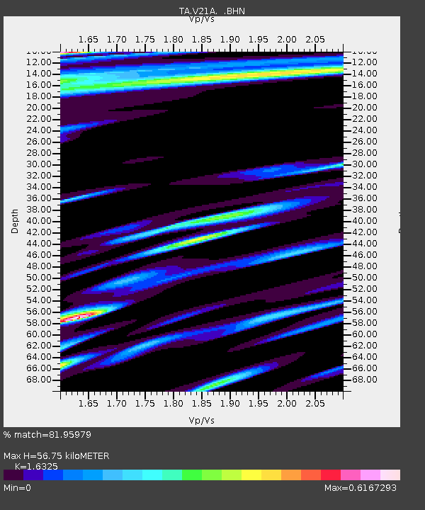
V21A Milan, NM, USA - Earthquake Result Viewer
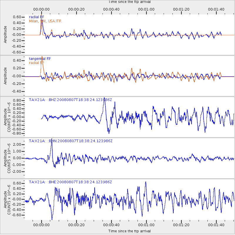
Earthquake location: Andreanof Islands, Aleutian Is.
Earthquake latitude/longitude: 52.2/-175.7
Earthquake time(UTC): 2008/08/07 (220) 18:30:03 GMT
Earthquake Depth: 12 km
Earthquake Magnitude: 5.6 MB, 5.5 MS, 5.8 MW, 5.8 MW
Earthquake Catalog/Contributor: WHDF/NEIC
Network: TA USArray Transportable Network (new EarthScope stations)
Station: V21A Milan, NM, USA
Lat/Lon: 35.81 N/107.64 W
Elevation: 2046 m
Distance: 49.7 deg
Az: 81.048 deg
Baz: 311.573 deg
Ray Param: 0.0685078
Estimated Moho Depth: 56.75 km
Estimated Crust Vp/Vs: 1.63
Assumed Crust Vp: 6.502 km/s
Estimated Crust Vs: 3.983 km/s
Estimated Crust Poisson's Ratio: 0.20
Radial Match: 81.95979 %
Radial Bump: 400
Transverse Match: 73.87884 %
Transverse Bump: 400
SOD ConfigId: 2504
Insert Time: 2010-03-06 19:05:42.610 +0000
GWidth: 2.5
Max Bumps: 400
Tol: 0.001

Signal To Noise

ChannelStoNSTALTA
TA:V21A: :BHN:20080807T18:38:24.123986Z4.8504182.9198125E-76.019713E-8
TA:V21A: :BHE:20080807T18:38:24.123986Z2.11582281.202481E-75.683279E-8
TA:V21A: :BHZ:20080807T18:38:24.123986Z2.53932641.5850674E-76.242078E-8
Arrivals
Ps5.9 SECOND
PpPs22 SECOND
PsPs/PpSs27 SECOND