You are here: Home > Network List > AZ - ANZA Regional Network Stations List
> Station SMER AZ.SMER > Earthquake Result Viewer
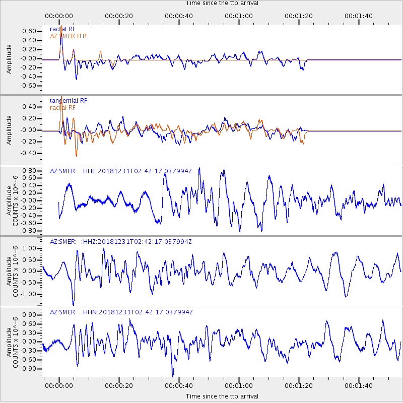
SMER AZ.SMER - Earthquake Result Viewer
*The percent match for this event was below the threshold and hence no stack was calculated.
| Earthquake location: |
Alaska Peninsula |
| Earthquake latitude/longitude: |
54.3/-161.4 |
| Earthquake time(UTC): |
2018/12/31 (365) 02:35:38 GMT |
| Earthquake Depth: |
34 km |
| Earthquake Magnitude: |
5.8 Mi |
| Earthquake Catalog/Contributor: |
NEIC PDE/at |
|
| Network: |
AZ ANZA Regional Network |
| Station: |
SMER AZ.SMER |
| Lat/Lon: |
33.46 N/117.17 W |
| Elevation: |
355 m |
|
| Distance: |
37.3 deg |
| Az: |
105.615 deg |
| Baz: |
317.479 deg |
| Ray Param: |
$rayparam |
*The percent match for this event was below the threshold and hence was not used in the summary stack. |
|
| Radial Match: |
73.03963 % |
| Radial Bump: |
400 |
| Transverse Match: |
57.366467 % |
| Transverse Bump: |
400 |
| SOD ConfigId: |
13570011 |
| Insert Time: |
2019-05-02 05:35:28.743 +0000 |
| GWidth: |
2.5 |
| Max Bumps: |
400 |
| Tol: |
0.001 |
|
Signal To Noise
| Channel | StoN | STA | LTA |
| AZ:SMER: :HHZ:20181231T02:42:17.037994Z | 2.4636712 | 4.9798706E-7 | 2.0213211E-7 |
| AZ:SMER: :HHN:20181231T02:42:17.037994Z | 1.3793035 | 2.0980588E-7 | 1.5211003E-7 |
| AZ:SMER: :HHE:20181231T02:42:17.037994Z | 2.2079937 | 3.8050072E-7 | 1.7232871E-7 |
| Arrivals |
| Ps | |
| PpPs | |
| PsPs/PpSs | |


