You are here: Home > Network List > TA - USArray Transportable Network (new EarthScope stations) Stations List
> Station V21A Milan, NM, USA > Earthquake Result Viewer
V21A Milan, NM, USA - Earthquake Result Viewer
| Earthquake location: |
Andreanof Islands, Aleutian Is. |
| Earthquake latitude/longitude: |
52.2/-178.7 |
| Earthquake time(UTC): |
2008/03/22 (082) 21:24:11 GMT |
| Earthquake Depth: |
132 km |
| Earthquake Magnitude: |
5.8 MB, 6.2 MW, 6.1 MW |
| Earthquake Catalog/Contributor: |
WHDF/NEIC |
|
| Network: |
TA USArray Transportable Network (new EarthScope stations) |
| Station: |
V21A Milan, NM, USA |
| Lat/Lon: |
35.81 N/107.64 W |
| Elevation: |
2046 m |
|
| Distance: |
51.6 deg |
| Az: |
78.891 deg |
| Baz: |
311.98 deg |
| Ray Param: |
0.06686531 |
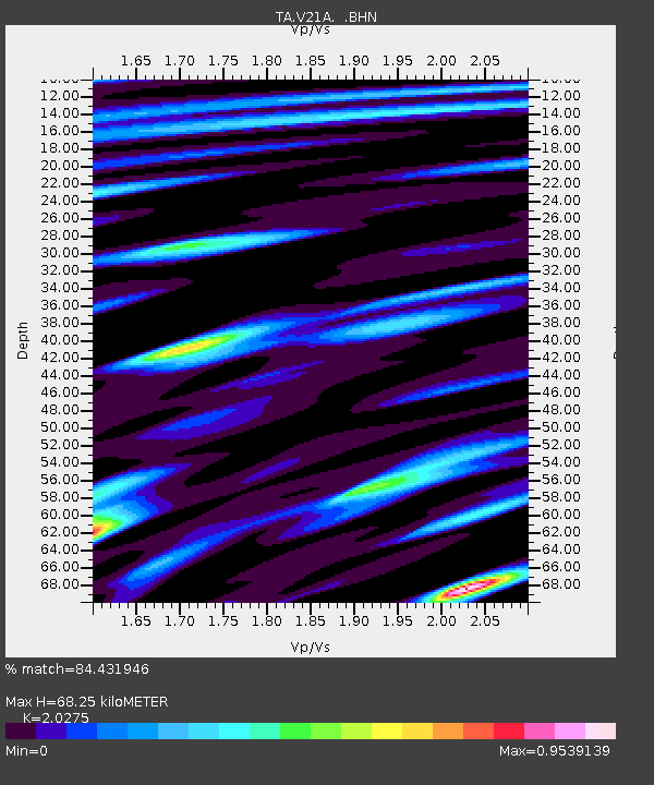
| Estimated Moho Depth: |
68.25 km |
| Estimated Crust Vp/Vs: |
2.03 |
| Assumed Crust Vp: |
6.502 km/s |
| Estimated Crust Vs: |
3.207 km/s |
| Estimated Crust Poisson's Ratio: |
0.34 |
|
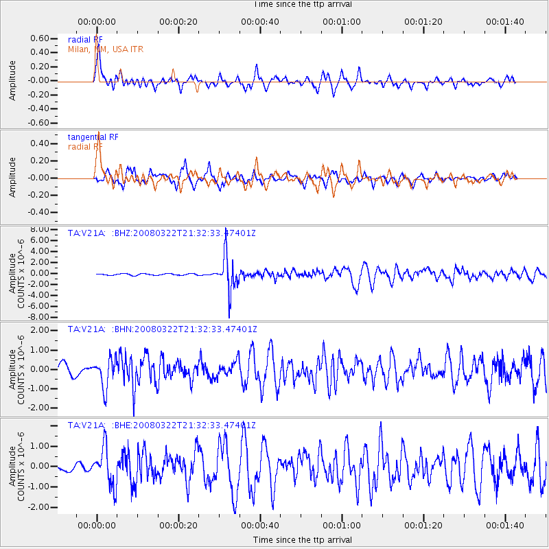
| Radial Match: |
84.431946 % |
| Radial Bump: |
400 |
| Transverse Match: |
77.68001 % |
| Transverse Bump: |
373 |
| SOD ConfigId: |
2564 |
| Insert Time: |
2010-03-06 19:05:54.307 +0000 |
| GWidth: |
2.5 |
| Max Bumps: |
400 |
| Tol: |
0.001 |
|
Signal To Noise
| Channel | StoN | STA | LTA |
| TA:V21A: :BHN:20080322T21:32:33.47401Z | 2.000453 | 7.6339813E-7 | 3.8161264E-7 |
| TA:V21A: :BHE:20080322T21:32:33.47401Z | 7.245253 | 9.662117E-7 | 1.3335789E-7 |
| TA:V21A: :BHZ:20080322T21:32:33.47401Z | 21.597528 | 3.17362E-6 | 1.4694366E-7 |
| Arrivals |
| Ps | 11 SECOND |
| PpPs | 30 SECOND |
| PsPs/PpSs | 42 SECOND |


