You are here: Home > Network List > TA - USArray Transportable Network (new EarthScope stations) Stations List
> Station V21A Milan, NM, USA > Earthquake Result Viewer
V21A Milan, NM, USA - Earthquake Result Viewer
| Earthquake location: |
East Of Kuril Islands |
| Earthquake latitude/longitude: |
46.9/155.2 |
| Earthquake time(UTC): |
2009/01/15 (015) 17:49:39 GMT |
| Earthquake Depth: |
36 km |
| Earthquake Magnitude: |
6.9 MB, 7.5 MS, 7.4 MW, 7.4 MW |
| Earthquake Catalog/Contributor: |
WHDF/NEIC |
|
| Network: |
TA USArray Transportable Network (new EarthScope stations) |
| Station: |
V21A Milan, NM, USA |
| Lat/Lon: |
35.81 N/107.64 W |
| Elevation: |
2046 m |
|
| Distance: |
69.3 deg |
| Az: |
59.56 deg |
| Baz: |
313.291 deg |
| Ray Param: |
0.05568763 |
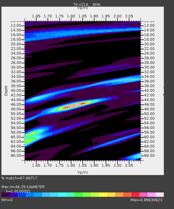
| Estimated Moho Depth: |
46.25 km |
| Estimated Crust Vp/Vs: |
1.81 |
| Assumed Crust Vp: |
6.502 km/s |
| Estimated Crust Vs: |
3.592 km/s |
| Estimated Crust Poisson's Ratio: |
0.28 |
|
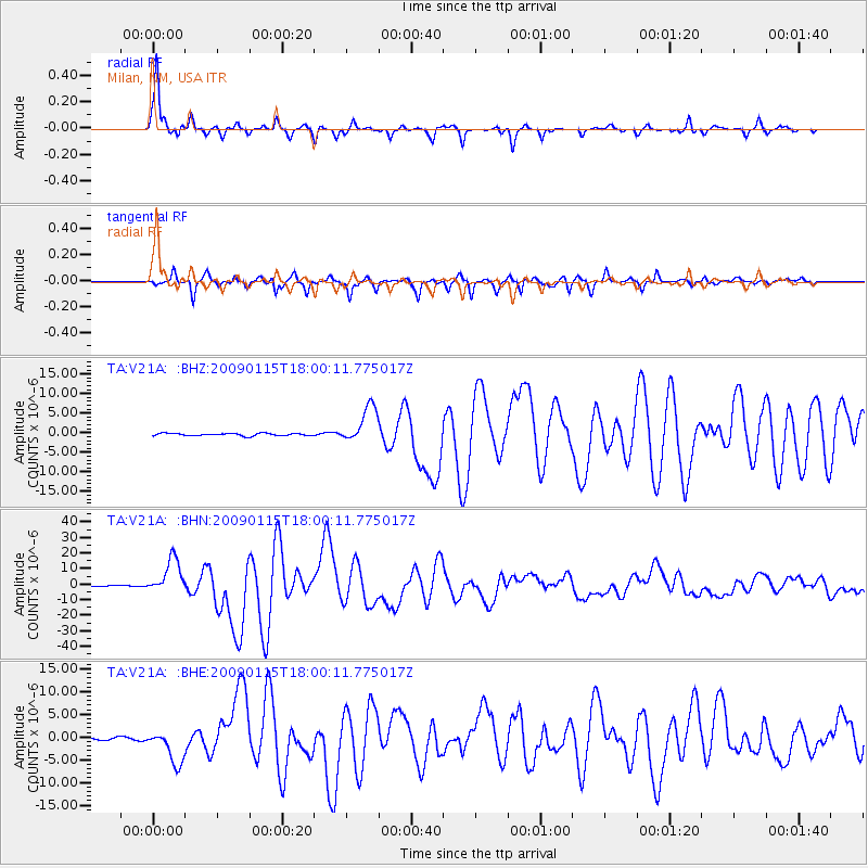
| Radial Match: |
97.66717 % |
| Radial Bump: |
267 |
| Transverse Match: |
96.15003 % |
| Transverse Bump: |
354 |
| SOD ConfigId: |
2834 |
| Insert Time: |
2010-03-06 19:05:59.431 +0000 |
| GWidth: |
2.5 |
| Max Bumps: |
400 |
| Tol: |
0.001 |
|
Signal To Noise
| Channel | StoN | STA | LTA |
| TA:V21A: :BHN:20090115T18:00:11.775017Z | 28.47705 | 1.12758225E-5 | 3.9596173E-7 |
| TA:V21A: :BHE:20090115T18:00:11.775017Z | 7.9593363 | 3.760268E-6 | 4.724349E-7 |
| TA:V21A: :BHZ:20090115T18:00:11.775017Z | 15.519993 | 4.709583E-6 | 3.0345268E-7 |
| Arrivals |
| Ps | 6.0 SECOND |
| PpPs | 19 SECOND |
| PsPs/PpSs | 25 SECOND |


