You are here: Home > Network List > TA - USArray Transportable Network (new EarthScope stations) Stations List
> Station V21A Milan, NM, USA > Earthquake Result Viewer
V21A Milan, NM, USA - Earthquake Result Viewer

| Earthquake location: |
Near S. Coast Of Honshu, Japan |
| Earthquake latitude/longitude: |
33.2/137.9 |
| Earthquake time(UTC): |
2009/08/09 (221) 10:55:55 GMT |
| Earthquake Depth: |
297 km |
| Earthquake Magnitude: |
6.5 MB, 7.1 MW, 7.1 MW |
| Earthquake Catalog/Contributor: |
WHDF/NEIC |
|
| Network: |
TA USArray Transportable Network (new EarthScope stations) |
| Station: |
V21A Milan, NM, USA |
| Lat/Lon: |
35.81 N/107.64 W |
| Elevation: |
2046 m |
|
| Distance: |
88.0 deg |
| Az: |
47.783 deg |
| Baz: |
310.165 deg |
| Ray Param: |
0.042195 |
| Estimated Moho Depth: |
47.25 km |
| Estimated Crust Vp/Vs: |
1.74 |
| Assumed Crust Vp: |
6.502 km/s |
| Estimated Crust Vs: |
3.737 km/s |
| Estimated Crust Poisson's Ratio: |
0.25 |
|
| Radial Match: |
88.77428 % |
| Radial Bump: |
400 |
| Transverse Match: |
82.22967 % |
| Transverse Bump: |
400 |
| SOD ConfigId: |
2622 |
| Insert Time: |
2010-03-06 19:06:04.477 +0000 |
| GWidth: |
2.5 |
| Max Bumps: |
400 |
| Tol: |
0.001 |
|
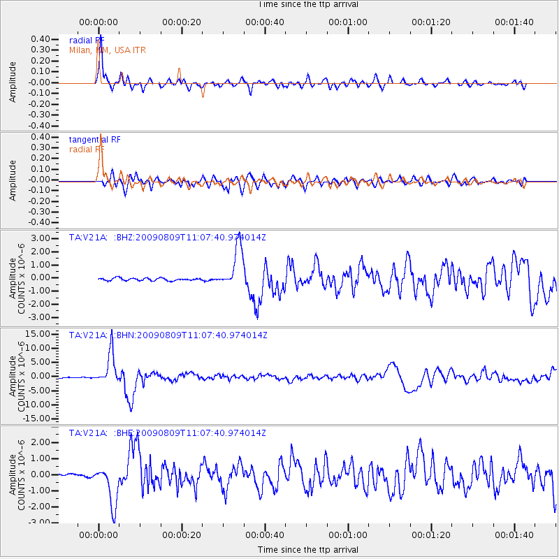
Signal To Noise
| Channel | StoN | STA | LTA |
| TA:V21A: :BHN:20090809T11:07:40.974014Z | 59.74543 | 5.7837533E-6 | 9.680662E-8 |
| TA:V21A: :BHE:20090809T11:07:40.974014Z | 12.156939 | 1.3125183E-6 | 1.0796454E-7 |
| TA:V21A: :BHZ:20090809T11:07:40.974014Z | 17.747152 | 1.6517643E-6 | 9.3072074E-8 |
| Arrivals |
| Ps | 5.5 SECOND |
| PpPs | 19 SECOND |
| PsPs/PpSs | 25 SECOND |


