You are here: Home > Network List > TS - TERRAscope (Southern California Seismic Network) Stations List
> Station CALB Calabasas, California, USA > Earthquake Result Viewer
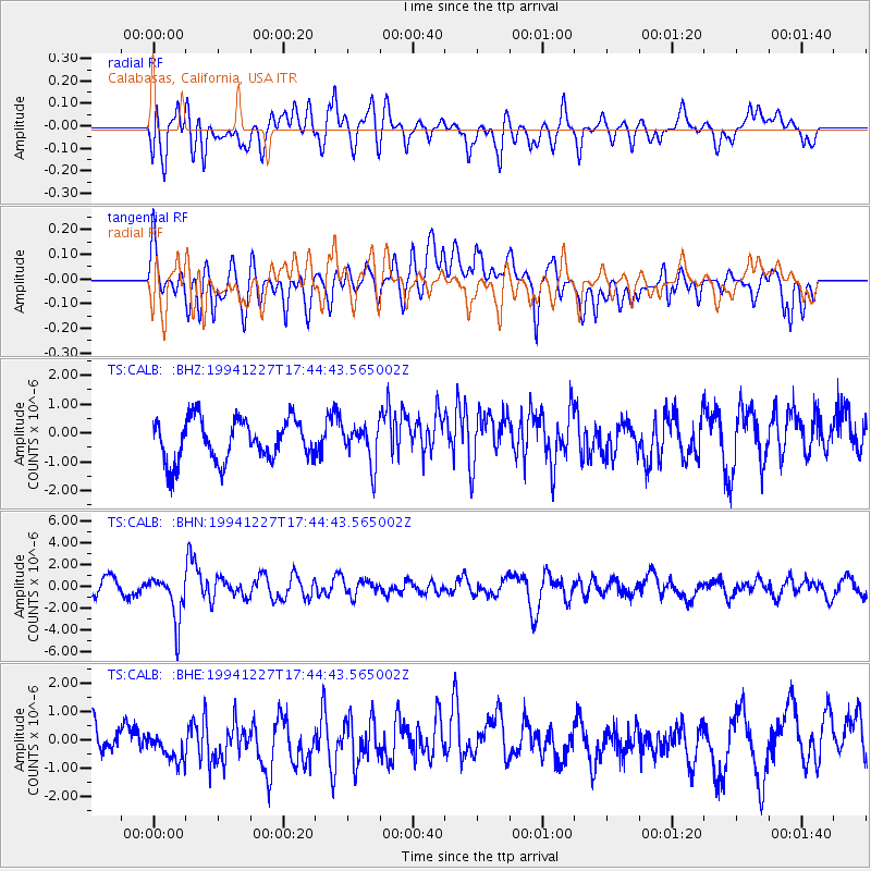
CALB Calabasas, California, USA - Earthquake Result Viewer
*The percent match for this event was below the threshold and hence no stack was calculated.
| Earthquake location: |
South Of Kermadec Islands |
| Earthquake latitude/longitude: |
-32.0/179.9 |
| Earthquake time(UTC): |
1994/12/27 (361) 17:32:52 GMT |
| Earthquake Depth: |
228 km |
| Earthquake Magnitude: |
6.0 MB, 6.1 UNKNOWN, 6.4 MW |
| Earthquake Catalog/Contributor: |
WHDF/NEIC |
|
| Network: |
TS TERRAscope (Southern California Seismic Network) |
| Station: |
CALB Calabasas, California, USA |
| Lat/Lon: |
34.14 N/118.63 W |
| Elevation: |
0.0 m |
|
| Distance: |
87.6 deg |
| Az: |
46.845 deg |
| Baz: |
228.357 deg |
| Ray Param: |
$rayparam |
*The percent match for this event was below the threshold and hence was not used in the summary stack. |
|
| Radial Match: |
61.2592 % |
| Radial Bump: |
400 |
| Transverse Match: |
66.27651 % |
| Transverse Bump: |
400 |
| SOD ConfigId: |
4480 |
| Insert Time: |
2010-02-26 14:03:09.587 +0000 |
| GWidth: |
2.5 |
| Max Bumps: |
400 |
| Tol: |
0.001 |
|
Signal To Noise
| Channel | StoN | STA | LTA |
| TS:CALB: :BHN:19941227T17:44:43.565002Z | 2.0235188 | 2.179535E-6 | 1.0771015E-6 |
| TS:CALB: :BHE:19941227T17:44:43.565002Z | 0.80836636 | 5.5922624E-7 | 6.9179805E-7 |
| TS:CALB: :BHZ:19941227T17:44:43.565002Z | 0.89971393 | 6.4994424E-7 | 7.2238987E-7 |
| Arrivals |
| Ps | |
| PpPs | |
| PsPs/PpSs | |


