You are here: Home > Network List > GB - Great Britain Seismograph Network Stations List
> Station FOEL TREGEIROG, WALES > Earthquake Result Viewer
FOEL TREGEIROG, WALES - Earthquake Result Viewer
| Earthquake location: |
Alaska Peninsula |
| Earthquake latitude/longitude: |
54.3/-161.4 |
| Earthquake time(UTC): |
2018/12/31 (365) 02:35:38 GMT |
| Earthquake Depth: |
34 km |
| Earthquake Magnitude: |
5.8 Mi |
| Earthquake Catalog/Contributor: |
NEIC PDE/at |
|
| Network: |
GB Great Britain Seismograph Network |
| Station: |
FOEL TREGEIROG, WALES |
| Lat/Lon: |
52.89 N/3.20 W |
| Elevation: |
449 m |
|
| Distance: |
71.7 deg |
| Az: |
13.7 deg |
| Baz: |
346.744 deg |
| Ray Param: |
0.054106086 |
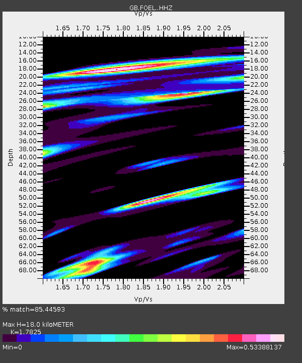
| Estimated Moho Depth: |
18.0 km |
| Estimated Crust Vp/Vs: |
1.78 |
| Assumed Crust Vp: |
6.276 km/s |
| Estimated Crust Vs: |
3.521 km/s |
| Estimated Crust Poisson's Ratio: |
0.27 |
|
| Radial Match: |
85.44593 % |
| Radial Bump: |
400 |
| Transverse Match: |
56.91241 % |
| Transverse Bump: |
400 |
| SOD ConfigId: |
13570011 |
| Insert Time: |
2019-05-02 05:37:58.584 +0000 |
| GWidth: |
2.5 |
| Max Bumps: |
400 |
| Tol: |
0.001 |
|

Signal To Noise
| Channel | StoN | STA | LTA |
| GB:FOEL: :HHZ:20181231T02:46:24.650024Z | 3.7225447 | 8.161923E-7 | 2.1925655E-7 |
| GB:FOEL: :HHN:20181231T02:46:24.650024Z | 2.1197705 | 4.4843844E-7 | 2.1155047E-7 |
| GB:FOEL: :HHE:20181231T02:46:24.650024Z | 1.133012 | 2.650365E-7 | 2.3392205E-7 |
| Arrivals |
| Ps | 2.3 SECOND |
| PpPs | 7.7 SECOND |
| PsPs/PpSs | 10 SECOND |


