You are here: Home > Network List > TA - USArray Transportable Network (new EarthScope stations) Stations List
> Station V21A Milan, NM, USA > Earthquake Result Viewer
V21A Milan, NM, USA - Earthquake Result Viewer

| Earthquake location: |
Sea Of Okhotsk |
| Earthquake latitude/longitude: |
54.2/154.3 |
| Earthquake time(UTC): |
2008/11/24 (329) 09:02:58 GMT |
| Earthquake Depth: |
492 km |
| Earthquake Magnitude: |
6.5 MB, 7.3 MW, 7.3 MW |
| Earthquake Catalog/Contributor: |
WHDF/NEIC |
|
| Network: |
TA USArray Transportable Network (new EarthScope stations) |
| Station: |
V21A Milan, NM, USA |
| Lat/Lon: |
35.81 N/107.64 W |
| Elevation: |
2046 m |
|
| Distance: |
66.1 deg |
| Az: |
61.655 deg |
| Baz: |
320.499 deg |
| Ray Param: |
0.0561016 |
| Estimated Moho Depth: |
59.75 km |
| Estimated Crust Vp/Vs: |
1.60 |
| Assumed Crust Vp: |
6.502 km/s |
| Estimated Crust Vs: |
4.063 km/s |
| Estimated Crust Poisson's Ratio: |
0.18 |
|
| Radial Match: |
85.573296 % |
| Radial Bump: |
304 |
| Transverse Match: |
68.42259 % |
| Transverse Bump: |
374 |
| SOD ConfigId: |
2658 |
| Insert Time: |
2010-03-06 19:06:23.482 +0000 |
| GWidth: |
2.5 |
| Max Bumps: |
400 |
| Tol: |
0.001 |
|
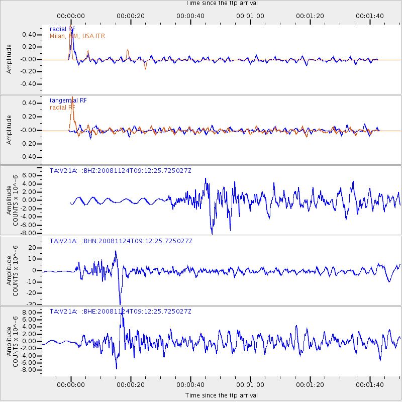
Signal To Noise
| Channel | StoN | STA | LTA |
| TA:V21A: :BHN:20081124T09:12:25.725027Z | 8.640377 | 3.2378773E-6 | 3.7473797E-7 |
| TA:V21A: :BHE:20081124T09:12:25.725027Z | 1.6288657 | 7.994541E-7 | 4.9080415E-7 |
| TA:V21A: :BHZ:20081124T09:12:25.725027Z | 1.3075738 | 6.7289255E-7 | 5.1461154E-7 |
| Arrivals |
| Ps | 5.8 SECOND |
| PpPs | 23 SECOND |
| PsPs/PpSs | 29 SECOND |


