You are here: Home > Network List > IC - New China Digital Seismograph Network Stations List
> Station KMI Kunming, Yunnan Province, China > Earthquake Result Viewer
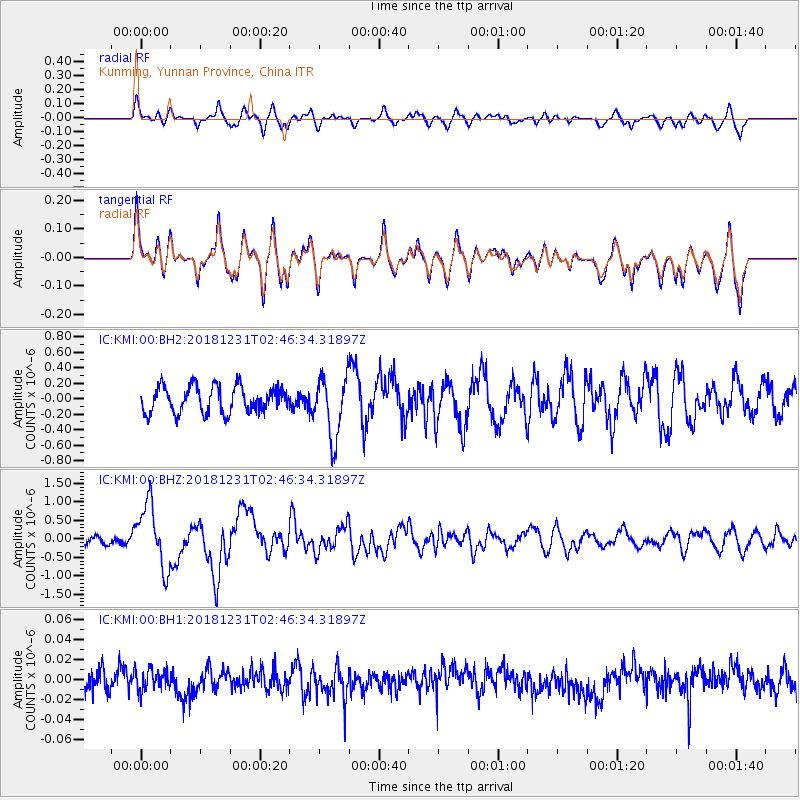
KMI Kunming, Yunnan Province, China - Earthquake Result Viewer
*The percent match for this event was below the threshold and hence no stack was calculated.
| Earthquake location: |
Alaska Peninsula |
| Earthquake latitude/longitude: |
54.3/-161.4 |
| Earthquake time(UTC): |
2018/12/31 (365) 02:35:38 GMT |
| Earthquake Depth: |
34 km |
| Earthquake Magnitude: |
5.8 Mi |
| Earthquake Catalog/Contributor: |
NEIC PDE/at |
|
| Network: |
IC New China Digital Seismograph Network |
| Station: |
KMI Kunming, Yunnan Province, China |
| Lat/Lon: |
25.12 N/102.74 E |
| Elevation: |
1975 m |
|
| Distance: |
73.3 deg |
| Az: |
289.674 deg |
| Baz: |
37.546 deg |
| Ray Param: |
$rayparam |
*The percent match for this event was below the threshold and hence was not used in the summary stack. |
|
| Radial Match: |
57.873413 % |
| Radial Bump: |
400 |
| Transverse Match: |
57.276093 % |
| Transverse Bump: |
400 |
| SOD ConfigId: |
13570011 |
| Insert Time: |
2019-05-02 05:38:30.153 +0000 |
| GWidth: |
2.5 |
| Max Bumps: |
400 |
| Tol: |
0.001 |
|
Signal To Noise
| Channel | StoN | STA | LTA |
| IC:KMI:00:BHZ:20181231T02:46:34.31897Z | 4.2151303 | 8.577023E-7 | 2.034818E-7 |
| IC:KMI:00:BH1:20181231T02:46:34.31897Z | 1.0290025 | 1.0232459E-8 | 9.944056E-9 |
| IC:KMI:00:BH2:20181231T02:46:34.31897Z | 2.4777443 | 4.1931008E-7 | 1.6923057E-7 |
| Arrivals |
| Ps | |
| PpPs | |
| PsPs/PpSs | |


