You are here: Home > Network List > TA - USArray Transportable Network (new EarthScope stations) Stations List
> Station V21A Milan, NM, USA > Earthquake Result Viewer
V21A Milan, NM, USA - Earthquake Result Viewer
| Earthquake location: |
Kuril Islands |
| Earthquake latitude/longitude: |
46.0/151.5 |
| Earthquake time(UTC): |
2009/04/07 (097) 04:23:33 GMT |
| Earthquake Depth: |
31 km |
| Earthquake Magnitude: |
6.5 MB, 6.8 MS, 6.9 MW, 6.9 MW |
| Earthquake Catalog/Contributor: |
WHDF/NEIC |
|
| Network: |
TA USArray Transportable Network (new EarthScope stations) |
| Station: |
V21A Milan, NM, USA |
| Lat/Lon: |
35.81 N/107.64 W |
| Elevation: |
2046 m |
|
| Distance: |
71.8 deg |
| Az: |
57.173 deg |
| Baz: |
313.948 deg |
| Ray Param: |
0.054017663 |
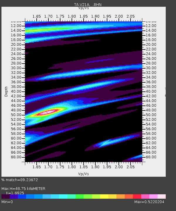
| Estimated Moho Depth: |
48.75 km |
| Estimated Crust Vp/Vs: |
1.69 |
| Assumed Crust Vp: |
6.502 km/s |
| Estimated Crust Vs: |
3.841 km/s |
| Estimated Crust Poisson's Ratio: |
0.23 |
|
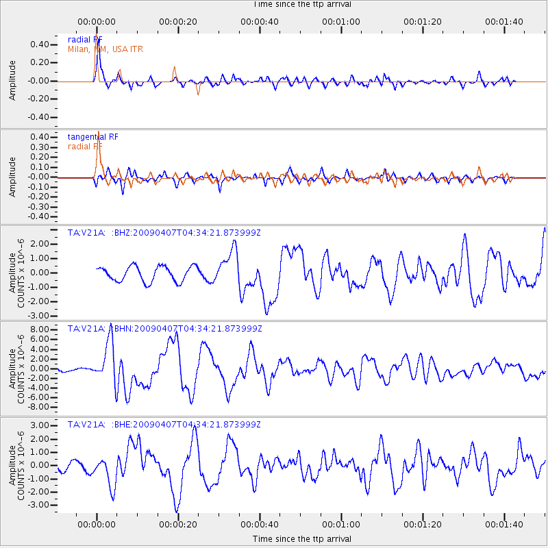
| Radial Match: |
89.23672 % |
| Radial Bump: |
386 |
| Transverse Match: |
76.32822 % |
| Transverse Bump: |
393 |
| SOD ConfigId: |
2658 |
| Insert Time: |
2010-03-06 19:06:32.416 +0000 |
| GWidth: |
2.5 |
| Max Bumps: |
400 |
| Tol: |
0.001 |
|
Signal To Noise
| Channel | StoN | STA | LTA |
| TA:V21A: :BHN:20090407T04:34:21.873999Z | 13.525754 | 4.4730987E-6 | 3.3070975E-7 |
| TA:V21A: :BHE:20090407T04:34:21.873999Z | 4.170852 | 1.1618207E-6 | 2.7855717E-7 |
| TA:V21A: :BHZ:20090407T04:34:21.873999Z | 2.3830204 | 1.2362406E-6 | 5.1877043E-7 |
| Arrivals |
| Ps | 5.4 SECOND |
| PpPs | 19 SECOND |
| PsPs/PpSs | 25 SECOND |


