You are here: Home > Network List > TA - USArray Transportable Network (new EarthScope stations) Stations List
> Station V21A Milan, NM, USA > Earthquake Result Viewer
V21A Milan, NM, USA - Earthquake Result Viewer
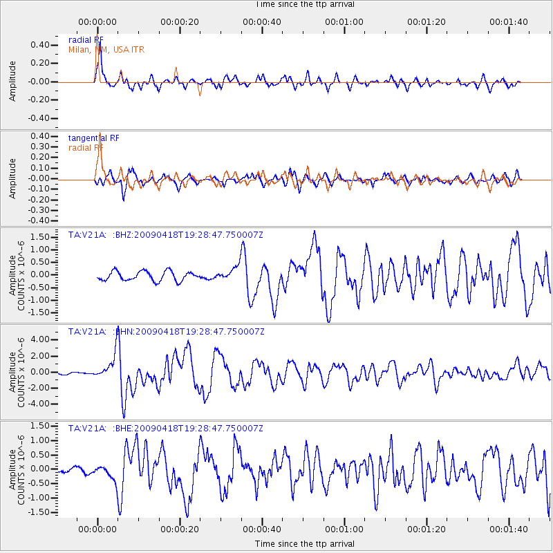
| Earthquake location: |
Kuril Islands |
| Earthquake latitude/longitude: |
46.0/151.4 |
| Earthquake time(UTC): |
2009/04/18 (108) 19:17:58 GMT |
| Earthquake Depth: |
35 km |
| Earthquake Magnitude: |
6.3 MB, 6.3 MS, 6.6 MW, 6.4 MW |
| Earthquake Catalog/Contributor: |
WHDF/NEIC |
|
| Network: |
TA USArray Transportable Network (new EarthScope stations) |
| Station: |
V21A Milan, NM, USA |
| Lat/Lon: |
35.81 N/107.64 W |
| Elevation: |
2046 m |
|
| Distance: |
71.9 deg |
| Az: |
57.091 deg |
| Baz: |
313.966 deg |
| Ray Param: |
0.053948957 |
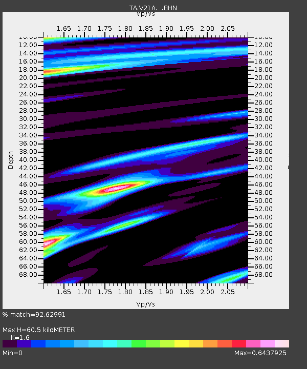
| Estimated Moho Depth: |
60.5 km |
| Estimated Crust Vp/Vs: |
1.60 |
| Assumed Crust Vp: |
6.502 km/s |
| Estimated Crust Vs: |
4.063 km/s |
| Estimated Crust Poisson's Ratio: |
0.18 |
|
| Radial Match: |
92.62991 % |
| Radial Bump: |
398 |
| Transverse Match: |
86.59924 % |
| Transverse Bump: |
400 |
| SOD ConfigId: |
2760 |
| Insert Time: |
2010-03-06 19:06:34.005 +0000 |
| GWidth: |
2.5 |
| Max Bumps: |
400 |
| Tol: |
0.001 |
|
Signal To Noise
| Channel | StoN | STA | LTA |
| TA:V21A: :BHN:20090418T19:28:47.750007Z | 11.755577 | 1.6492446E-6 | 1.4029466E-7 |
| TA:V21A: :BHE:20090418T19:28:47.750007Z | 1.6342963 | 2.7620604E-7 | 1.6900609E-7 |
| TA:V21A: :BHZ:20090418T19:28:47.750007Z | 1.5844985 | 2.9679848E-7 | 1.8731382E-7 |
| Arrivals |
| Ps | 5.8 SECOND |
| PpPs | 23 SECOND |
| PsPs/PpSs | 29 SECOND |


