You are here: Home > Network List > TA - USArray Transportable Network (new EarthScope stations) Stations List
> Station V21A Milan, NM, USA > Earthquake Result Viewer
V21A Milan, NM, USA - Earthquake Result Viewer
| Earthquake location: |
Off Coast Of Ecuador |
| Earthquake latitude/longitude: |
1.4/-85.2 |
| Earthquake time(UTC): |
2009/05/10 (130) 01:16:06 GMT |
| Earthquake Depth: |
6.0 km |
| Earthquake Magnitude: |
5.5 MB, 5.7 MS, 6.1 MW, 6.1 MW |
| Earthquake Catalog/Contributor: |
WHDF/NEIC |
|
| Network: |
TA USArray Transportable Network (new EarthScope stations) |
| Station: |
V21A Milan, NM, USA |
| Lat/Lon: |
35.81 N/107.64 W |
| Elevation: |
2046 m |
|
| Distance: |
40.1 deg |
| Az: |
331.159 deg |
| Baz: |
143.612 deg |
| Ray Param: |
0.07460369 |
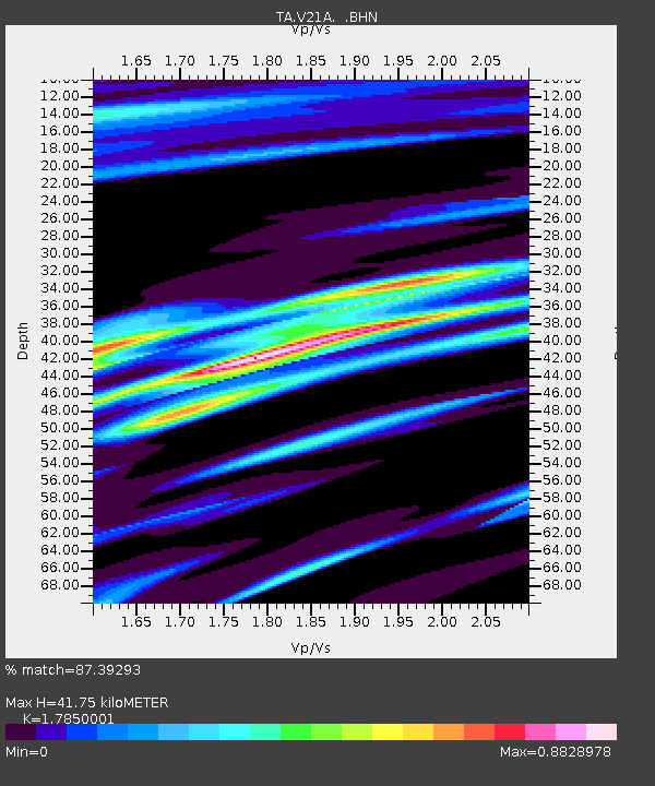
| Estimated Moho Depth: |
41.75 km |
| Estimated Crust Vp/Vs: |
1.79 |
| Assumed Crust Vp: |
6.502 km/s |
| Estimated Crust Vs: |
3.642 km/s |
| Estimated Crust Poisson's Ratio: |
0.27 |
|
| Radial Match: |
87.39293 % |
| Radial Bump: |
354 |
| Transverse Match: |
65.729324 % |
| Transverse Bump: |
342 |
| SOD ConfigId: |
2760 |
| Insert Time: |
2010-03-06 19:06:37.191 +0000 |
| GWidth: |
2.5 |
| Max Bumps: |
400 |
| Tol: |
0.001 |
|
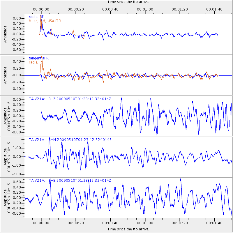
Signal To Noise
| Channel | StoN | STA | LTA |
| TA:V21A: :BHN:20090510T01:23:12.324014Z | 9.775053 | 6.679182E-7 | 6.832886E-8 |
| TA:V21A: :BHE:20090510T01:23:12.324014Z | 1.3647903 | 2.4109644E-7 | 1.7665455E-7 |
| TA:V21A: :BHZ:20090510T01:23:12.324014Z | 1.1579058 | 1.3659104E-7 | 1.17963864E-7 |
| Arrivals |
| Ps | 5.4 SECOND |
| PpPs | 17 SECOND |
| PsPs/PpSs | 22 SECOND |


