You are here: Home > Network List > TA - USArray Transportable Network (new EarthScope stations) Stations List
> Station V21A Milan, NM, USA > Earthquake Result Viewer
V21A Milan, NM, USA - Earthquake Result Viewer

| Earthquake location: |
Loyalty Islands |
| Earthquake latitude/longitude: |
-20.1/168.9 |
| Earthquake time(UTC): |
2008/04/09 (100) 12:46:12 GMT |
| Earthquake Depth: |
33 km |
| Earthquake Magnitude: |
6.3 MB, 7.3 MS, 7.3 MW, 7.3 MW |
| Earthquake Catalog/Contributor: |
WHDF/NEIC |
|
| Network: |
TA USArray Transportable Network (new EarthScope stations) |
| Station: |
V21A Milan, NM, USA |
| Lat/Lon: |
35.81 N/107.64 W |
| Elevation: |
2046 m |
|
| Distance: |
96.4 deg |
| Az: |
54.36 deg |
| Baz: |
250.018 deg |
| Ray Param: |
0.040505037 |
| Estimated Moho Depth: |
48.25 km |
| Estimated Crust Vp/Vs: |
1.79 |
| Assumed Crust Vp: |
6.502 km/s |
| Estimated Crust Vs: |
3.627 km/s |
| Estimated Crust Poisson's Ratio: |
0.27 |
|
| Radial Match: |
92.34024 % |
| Radial Bump: |
230 |
| Transverse Match: |
73.07571 % |
| Transverse Bump: |
294 |
| SOD ConfigId: |
2504 |
| Insert Time: |
2010-03-06 19:06:40.031 +0000 |
| GWidth: |
2.5 |
| Max Bumps: |
400 |
| Tol: |
0.001 |
|
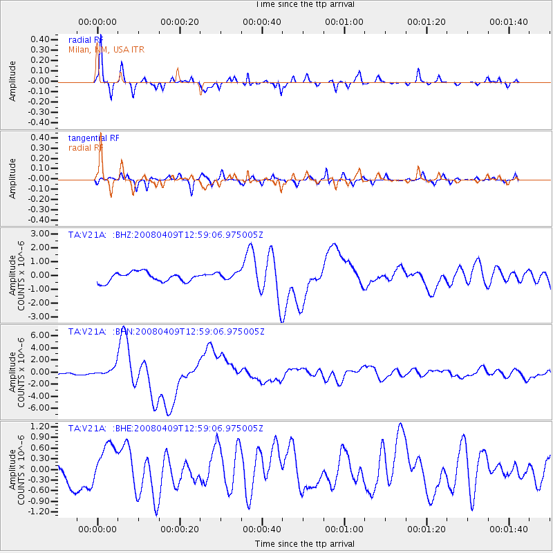
Signal To Noise
| Channel | StoN | STA | LTA |
| TA:V21A: :BHN:20080409T12:59:06.975005Z | 5.0861025 | 8.1594624E-7 | 1.6042662E-7 |
| TA:V21A: :BHE:20080409T12:59:06.975005Z | 1.7758868 | 5.600991E-7 | 3.1539125E-7 |
| TA:V21A: :BHZ:20080409T12:59:06.975005Z | 0.8094869 | 2.7341062E-7 | 3.3775794E-7 |
| Arrivals |
| Ps | 6.0 SECOND |
| PpPs | 20 SECOND |
| PsPs/PpSs | 26 SECOND |


