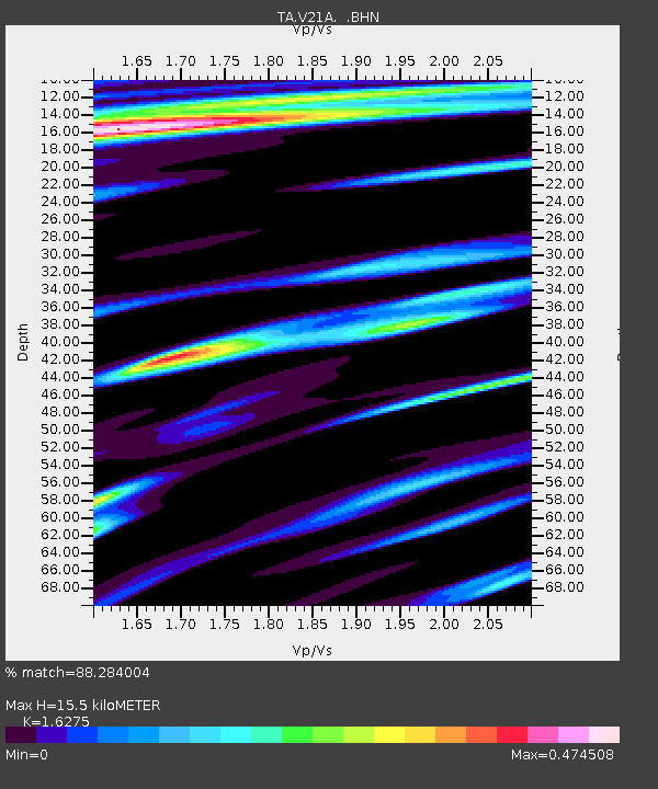
V21A Milan, NM, USA - Earthquake Result Viewer
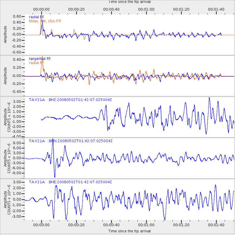
Earthquake location: Andreanof Islands, Aleutian Is.
Earthquake latitude/longitude: 51.9/-177.5
Earthquake time(UTC): 2008/05/02 (123) 01:33:37 GMT
Earthquake Depth: 14 km
Earthquake Magnitude: 6.3 MB, 6.8 MS, 6.6 MW, 6.6 MW
Earthquake Catalog/Contributor: WHDF/NEIC
Network: TA USArray Transportable Network (new EarthScope stations)
Station: V21A Milan, NM, USA
Lat/Lon: 35.81 N/107.64 W
Elevation: 2046 m
Distance: 50.9 deg
Az: 79.468 deg
Baz: 311.41 deg
Ray Param: 0.06772096
Estimated Moho Depth: 15.5 km
Estimated Crust Vp/Vs: 1.63
Assumed Crust Vp: 6.502 km/s
Estimated Crust Vs: 3.995 km/s
Estimated Crust Poisson's Ratio: 0.20
Radial Match: 88.284004 %
Radial Bump: 378
Transverse Match: 76.879074 %
Transverse Bump: 400
SOD ConfigId: 2504
Insert Time: 2010-03-06 19:06:44.399 +0000
GWidth: 2.5
Max Bumps: 400
Tol: 0.001

Signal To Noise

ChannelStoNSTALTA
TA:V21A: :BHN:20080502T01:42:07.025004Z9.9644621.4461987E-61.4513564E-7
TA:V21A: :BHE:20080502T01:42:07.025004Z2.44556165.199284E-72.1260081E-7
TA:V21A: :BHZ:20080502T01:42:07.025004Z3.11562637.1567285E-72.2970433E-7
Arrivals
Ps1.6 SECOND
PpPs5.9 SECOND
PsPs/PpSs7.5 SECOND