You are here: Home > Network List > CI - Caltech Regional Seismic Network Stations List
> Station MPM Manuel Prospect Mine, California, USA > Earthquake Result Viewer
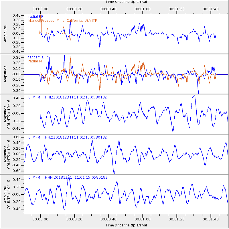
MPM Manuel Prospect Mine, California, USA - Earthquake Result Viewer
*The percent match for this event was below the threshold and hence no stack was calculated.
| Earthquake location: |
San Juan Province, Argentina |
| Earthquake latitude/longitude: |
-31.8/-69.3 |
| Earthquake time(UTC): |
2018/12/31 (365) 10:49:41 GMT |
| Earthquake Depth: |
101 km |
| Earthquake Magnitude: |
5.3 Mww |
| Earthquake Catalog/Contributor: |
NEIC PDE/us |
|
| Network: |
CI Caltech Regional Seismic Network |
| Station: |
MPM Manuel Prospect Mine, California, USA |
| Lat/Lon: |
36.06 N/117.49 W |
| Elevation: |
185 m |
|
| Distance: |
81.2 deg |
| Az: |
322.331 deg |
| Baz: |
140.031 deg |
| Ray Param: |
$rayparam |
*The percent match for this event was below the threshold and hence was not used in the summary stack. |
|
| Radial Match: |
38.434532 % |
| Radial Bump: |
400 |
| Transverse Match: |
65.33853 % |
| Transverse Bump: |
400 |
| SOD ConfigId: |
13570011 |
| Insert Time: |
2019-05-02 05:45:44.290 +0000 |
| GWidth: |
2.5 |
| Max Bumps: |
400 |
| Tol: |
0.001 |
|
Signal To Noise
| Channel | StoN | STA | LTA |
| CI:MPM: :HHZ:20181231T11:01:15.058018Z | 0.6671411 | 1.6254603E-7 | 2.4364564E-7 |
| CI:MPM: :HHN:20181231T11:01:15.058018Z | 0.9877469 | 1.398099E-7 | 1.4154425E-7 |
| CI:MPM: :HHE:20181231T11:01:15.058018Z | 1.0299681 | 1.5912909E-7 | 1.5449905E-7 |
| Arrivals |
| Ps | |
| PpPs | |
| PsPs/PpSs | |


