You are here: Home > Network List > TA - USArray Transportable Network (new EarthScope stations) Stations List
> Station V21A Milan, NM, USA > Earthquake Result Viewer
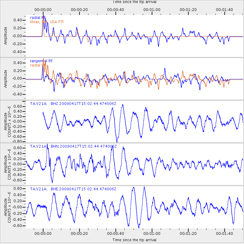
V21A Milan, NM, USA - Earthquake Result Viewer
*The percent match for this event was below the threshold and hence no stack was calculated.
| Earthquake location: |
Kuril Islands |
| Earthquake latitude/longitude: |
46.2/151.7 |
| Earthquake time(UTC): |
2009/04/17 (107) 14:51:58 GMT |
| Earthquake Depth: |
49 km |
| Earthquake Magnitude: |
5.5 MB, 5.0 MS, 5.7 MW, 5.6 MW |
| Earthquake Catalog/Contributor: |
WHDF/NEIC |
|
| Network: |
TA USArray Transportable Network (new EarthScope stations) |
| Station: |
V21A Milan, NM, USA |
| Lat/Lon: |
35.81 N/107.64 W |
| Elevation: |
2046 m |
|
| Distance: |
71.7 deg |
| Az: |
57.298 deg |
| Baz: |
313.992 deg |
| Ray Param: |
$rayparam |
*The percent match for this event was below the threshold and hence was not used in the summary stack. |
|
| Radial Match: |
53.116226 % |
| Radial Bump: |
393 |
| Transverse Match: |
54.387352 % |
| Transverse Bump: |
398 |
| SOD ConfigId: |
2658 |
| Insert Time: |
2010-03-06 19:08:26.933 +0000 |
| GWidth: |
2.5 |
| Max Bumps: |
400 |
| Tol: |
0.001 |
|
Signal To Noise
| Channel | StoN | STA | LTA |
| TA:V21A: :BHN:20090417T15:02:44.474006Z | 2.417444 | 3.4588072E-7 | 1.4307703E-7 |
| TA:V21A: :BHE:20090417T15:02:44.474006Z | 1.1243315 | 1.9654577E-7 | 1.7481123E-7 |
| TA:V21A: :BHZ:20090417T15:02:44.474006Z | 0.6609462 | 1.2080517E-7 | 1.8277612E-7 |
| Arrivals |
| Ps | |
| PpPs | |
| PsPs/PpSs | |


