You are here: Home > Network List > TA - USArray Transportable Network (new EarthScope stations) Stations List
> Station L15K Ungalak Mountain, AK, USA > Earthquake Result Viewer
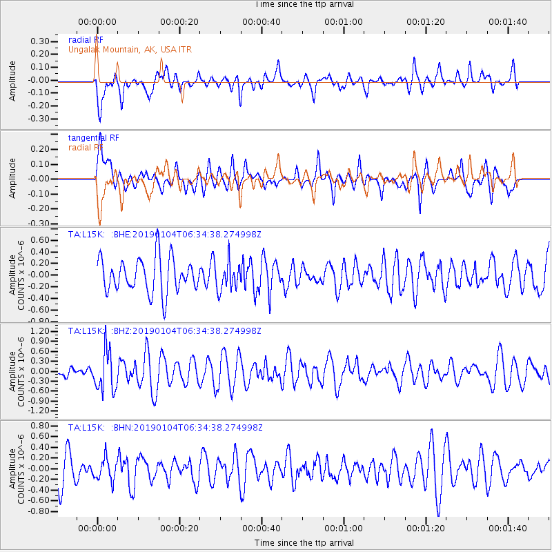
L15K Ungalak Mountain, AK, USA - Earthquake Result Viewer
*The percent match for this event was below the threshold and hence no stack was calculated.
| Earthquake location: |
Banda Sea |
| Earthquake latitude/longitude: |
-6.5/130.4 |
| Earthquake time(UTC): |
2019/01/04 (004) 06:22:44 GMT |
| Earthquake Depth: |
118 km |
| Earthquake Magnitude: |
5.6 Mww |
| Earthquake Catalog/Contributor: |
NEIC PDE/us |
|
| Network: |
TA USArray Transportable Network (new EarthScope stations) |
| Station: |
L15K Ungalak Mountain, AK, USA |
| Lat/Lon: |
61.68 N/161.49 W |
| Elevation: |
219 m |
|
| Distance: |
85.5 deg |
| Az: |
26.352 deg |
| Baz: |
247.646 deg |
| Ray Param: |
$rayparam |
*The percent match for this event was below the threshold and hence was not used in the summary stack. |
|
| Radial Match: |
56.64095 % |
| Radial Bump: |
400 |
| Transverse Match: |
56.843067 % |
| Transverse Bump: |
400 |
| SOD ConfigId: |
13570011 |
| Insert Time: |
2019-05-02 05:55:11.206 +0000 |
| GWidth: |
2.5 |
| Max Bumps: |
400 |
| Tol: |
0.001 |
|
Signal To Noise
| Channel | StoN | STA | LTA |
| TA:L15K: :BHZ:20190104T06:34:38.274998Z | 1.8777069 | 6.1145886E-7 | 3.2564128E-7 |
| TA:L15K: :BHN:20190104T06:34:38.274998Z | 0.6814288 | 2.0664007E-7 | 3.032453E-7 |
| TA:L15K: :BHE:20190104T06:34:38.274998Z | 0.8186705 | 2.4183933E-7 | 2.9540496E-7 |
| Arrivals |
| Ps | |
| PpPs | |
| PsPs/PpSs | |


